IMAGES TAKEN NEAR TO
High Dyke, GRANTHAM, NG33 5BD
Introduction
This page details the photographs taken nearby to High Dyke, NG33 5BD by members of the Geograph project.
The Geograph project started in 2005 with the aim of publishing, organising and preserving representative images for every square kilometre of Great Britain, Ireland and the Isle of Man.

There are currently over 7.5m images from over14,400 individuals and you can help contribute to the project by visiting https://www.geograph.org.uk
Image Map
Images are licensed for reuse under creativecommons.org/licenses/by-sa/2.0
Notes
- Clicking on the map will re-center to the selected point.
- The higher the marker number, the further away the image location is from the centre of the postcode.
Image Listing (5 Images Found)
Images are licensed for reuse under creativecommons.org/licenses/by-sa/2.0
Image
Details
Distance
2
Farm Ford on the River Witham, Stoke Rochford
This is the third of the three fords on this stretch of the River Witham near Washdike Road just off the A1.
Image: © John Walton
Taken: 21 Aug 2010
0.14 miles
3

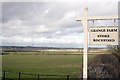
Farm Ford on the River Witham near Grange Farm
This farm ford is one of three on this stretch of the River Witham near Washdike Lane at Stoke Rochford just off the A1.
Image: © John Walton
Taken: 21 Aug 2010
0.16 miles
4
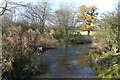
Washdike Lane Ford across the River Witham
On the far side the lane runs to the A1 and Stoke Rochford
Image: © Tim Heaton
Taken: 1 Dec 2013
0.20 miles
5
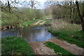
Washdike Lane Ford at Stoke Rochford
This ford is found on the farm track leading off the A1 on the opposite side from the village of Stoke Rochford. The ford spans the River Witham.
Image: © John Walton
Taken: 16 Apr 2010
0.22 miles