IMAGES TAKEN NEAR TO
Easton, GRANTHAM, NG33 5AW
Introduction
This page details the photographs taken nearby to NG33 5AW by members of the Geograph project.
The Geograph project started in 2005 with the aim of publishing, organising and preserving representative images for every square kilometre of Great Britain, Ireland and the Isle of Man.

There are currently over 7.5m images from over14,400 individuals and you can help contribute to the project by visiting https://www.geograph.org.uk
Image Map
Images are licensed for reuse under creativecommons.org/licenses/by-sa/2.0
Notes
- Clicking on the map will re-center to the selected point.
- The higher the marker number, the further away the image location is from the centre of the postcode.
Image Listing (27 Images Found)
Images are licensed for reuse under creativecommons.org/licenses/by-sa/2.0
Image
Details
Distance
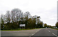
3
A1 southbound junction with Crabtree Road
To Buckminster, due west.
Image: © Julian P Guffogg
Taken: 7 May 2013
0.07 miles
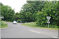
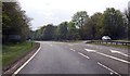
4
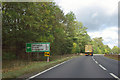
A1 - approaching turning for Skillington
The side road is called Crabtree Road.
Image: © Robin Webster
Taken: 7 Oct 2011
0.11 miles
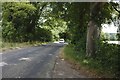
5

A tunnel of trees
Another view of Crabtree Lane
Image: © Bob Harvey
Taken: 8 Jul 2018
0.12 miles
6
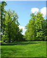
Avenue, Easton
Looking towards the A1 through the Montague gates. Although a track is marked on the map, there is only the ghost of one on the ground.
Image: © Kate Nicol
Taken: 3 May 2009
0.14 miles
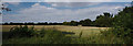
8
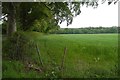
Beside Crabtree Road
A field beyond a tree lined road.
Image: © Richard Webb
Taken: 21 May 2016
0.15 miles
9
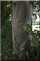
Old Graffiti
Initial carved into the tree seen in Image
Image: © Bob Harvey
Taken: 8 Jul 2018
0.15 miles