IMAGES TAKEN NEAR TO
Easton, GRANTHAM, NG33 5AU
Introduction
This page details the photographs taken nearby to NG33 5AU by members of the Geograph project.
The Geograph project started in 2005 with the aim of publishing, organising and preserving representative images for every square kilometre of Great Britain, Ireland and the Isle of Man.

There are currently over 7.5m images from over14,400 individuals and you can help contribute to the project by visiting https://www.geograph.org.uk
Image Map
Images are licensed for reuse under creativecommons.org/licenses/by-sa/2.0
Notes
- Clicking on the map will re-center to the selected point.
- The higher the marker number, the further away the image location is from the centre of the postcode.
Image Listing (10 Images Found)
Images are licensed for reuse under creativecommons.org/licenses/by-sa/2.0
Image
Details
Distance
1
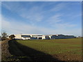
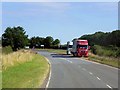
Christian Salvesen's 'Easton Cold Store'
Cold storage depot for refrigerated lorries, with easy access to the A1
Image: © Tim Heaton
Taken: 19 Nov 2006
0.06 miles
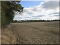
4
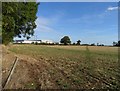
Track
There is a Norbert Dentressangle distribution centre and a McCains frozen food factory in the background.
Image: © Andrew Tatlow
Taken: 26 Sep 2011
0.13 miles
7
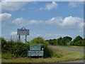
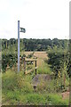
Signs for Easton Walled Gardens
At the eastern end of Planting Lane
Image: © Richard Humphrey
Taken: 12 Jul 2015
0.18 miles