IMAGES TAKEN NEAR TO
Top Cottages, GRANTHAM, NG33 5AD
Introduction
This page details the photographs taken nearby to Top Cottages, NG33 5AD by members of the Geograph project.
The Geograph project started in 2005 with the aim of publishing, organising and preserving representative images for every square kilometre of Great Britain, Ireland and the Isle of Man.

There are currently over 7.5m images from over14,400 individuals and you can help contribute to the project by visiting https://www.geograph.org.uk
Image Map (Loading...)


Getting Data...Please wait
Leaflet Map data © OpenStreetMap
Images are licensed for reuse under creativecommons.org/licenses/by-sa/2.0
Notes
- Clicking on the map will re-center to the selected point.
- The higher the marker number, the further away the image location is from the centre of the postcode.
Image Listing (7 Images Found)
Images are licensed for reuse under creativecommons.org/licenses/by-sa/2.0
Image
Details
Distance
1
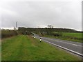
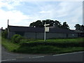
Ermine Street
Ermine Street with Ponton Park Woods in the background.
Image: © Andrew Tatlow
Taken: 19 Apr 2006
0.09 miles
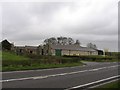

4
Woodnook Farm house
From the lane leading to Little Ponton through Woodnook valley.
Image: © Kate Jewell
Taken: 30 Jul 2006
0.18 miles
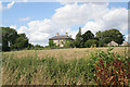
7
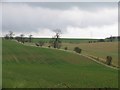
Fields opposite Woodnook Farm
Newly planted hedges to be noted.
Image: © Andrew Tatlow
Taken: 19 Apr 2006
0.24 miles