IMAGES TAKEN NEAR TO
Grimsthorpe Park, GRANTHAM, NG33 4RB
Introduction
This page details the photographs taken nearby to Grimsthorpe Park, NG33 4RB by members of the Geograph project.
The Geograph project started in 2005 with the aim of publishing, organising and preserving representative images for every square kilometre of Great Britain, Ireland and the Isle of Man.

There are currently over 7.5m images from over14,400 individuals and you can help contribute to the project by visiting https://www.geograph.org.uk
Image Map
Images are licensed for reuse under creativecommons.org/licenses/by-sa/2.0
Notes
- Clicking on the map will re-center to the selected point.
- The higher the marker number, the further away the image location is from the centre of the postcode.
Image Listing (6 Images Found)
Images are licensed for reuse under creativecommons.org/licenses/by-sa/2.0
Image
Details
Distance
1

Chestnut Avenue
Farm buildings on Chestnut Avenue near Red Deer Cottage
Image: © Richard Croft
Taken: 12 Jul 2012
0.05 miles
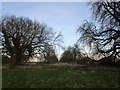
2

Chestnut Avenue
Looking towards Red Deer Cottage in Grimsthorpe deer park
Image: © Richard Croft
Taken: 12 Jul 2012
0.08 miles
3
Avenue of horse chestnut trees on Bytham Riding
The trees are badly affected by leaf blotch
Image: © Tim Heaton
Taken: 12 Jul 2017
0.12 miles
4
Kennel Riding
Grimsthorpe Park is criss-crossed with Ridings (rides). Some are public footpaths, others are used by estate workers but this one seems to be largely abandoned.
Image: © Jonathan Thacker
Taken: 10 Jan 2020
0.14 miles
5

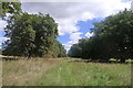
Grimsthorpe deer park
View from Chestnut Avenue towards Bytham Park Plantation
Image: © Richard Croft
Taken: 12 Jul 2012
0.18 miles
6
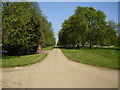
Chestnut Avenue to Grimsthorpe Castle
Taken from the footpath.
Image: © Ken Brockway
Taken: 15 Apr 2007
0.21 miles