IMAGES TAKEN NEAR TO
Station Road, GRANTHAM, NG33 4RA
Introduction
This page details the photographs taken nearby to Station Road, NG33 4RA by members of the Geograph project.
The Geograph project started in 2005 with the aim of publishing, organising and preserving representative images for every square kilometre of Great Britain, Ireland and the Isle of Man.

There are currently over 7.5m images from over14,400 individuals and you can help contribute to the project by visiting https://www.geograph.org.uk
Image Map
Images are licensed for reuse under creativecommons.org/licenses/by-sa/2.0
Notes
- Clicking on the map will re-center to the selected point.
- The higher the marker number, the further away the image location is from the centre of the postcode.
Image Listing (80 Images Found)
Images are licensed for reuse under creativecommons.org/licenses/by-sa/2.0
Image
Details
Distance
1

Road junction and grass triangle
Seen in Little Bytham.
Image: © Michael Trolove
Taken: 2 Oct 2016
0.05 miles
2
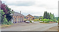
Remains of former Little Bytham station, ECML 1992
View along Station Road, showing the Up side station buildings put to different use after closure to passengers 15/6/59, to goods 1/11/65. On the ex-GNR King's Cross - Doncaster section of the ECML, it is well-known as the location of the 1938 World Record for Steam Locomotion. (Cf. Image, Image and Image).
Image: © Ben Brooksbank
Taken: 16 Jun 1992
0.06 miles
3
Railway viaduct at Little Bytham, near Bourne, Lincolnshire
The village of Little Bytham can be found on the B1176 four miles south west of Bourne, nestling around two grand Victorian viaducts, one of them disused and the other carrying the main east coast line between London and Scotland. It was on this stretch of track between Grantham and Peterborough on 3rd July 1938 that the LNER locomotive Mallard achieved the highest speed ever ratified for a steam locomotive of 126 mph that has not been beaten and the village has since been a popular call for visiting railway buffs.
Image: © Rex Needle
Taken: 9 Sep 1999
0.06 miles
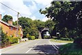
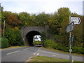
4
Little Bytham: roads, roofers and an abandoned railway
The bridge and the embankments each side once carried the line from Saxby Junction, near Melton Mowbray, to Bourne, which closed early in 1959. This was part of the Midland & Great Northern system, which carried holidaymakers from the Midlands to the Norfolk coast. This line crossed the East Coast Main Line at right angles on a girder bridge which was removed years ago. The gardens of the houses on the left end at the embankment which carries the ECML (see the map extract which accompanies this Geograph image).
Image: © John Sutton
Taken: 25 Oct 2023
0.06 miles
5

Little Bytham: signpost and autumn sunlight
The winding B1176 links Grantham (left) and Stamford. The discoloured finger of the signpost points to Witham on the Hill and Bourne.
Image: © John Sutton
Taken: 25 Oct 2023
0.06 miles
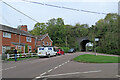
6
Railway viaduct
This carried the Midland Railway's line linking just to the east with the Midland & Great Northern Joint Railway, which closed in 1959.
Image: © Bikeboy
Taken: 14 Apr 2015
0.08 miles
7
Disused Railway Bridge, Station Road, Little Bytham
See Image
Image: © Stephen Armstrong
Taken: 5 Oct 2009
0.08 miles
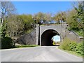
8

Disused railway bridge
This bridge carried the railway line from Saxby to Bourne from 1894, and the line was in use until late in the 1950s.
Image: © Brian Green
Taken: 6 Jan 2008
0.09 miles

10

Little Bytham: Mulberry Motor Company
Part of a small industrial estate in the lee of the East Coast Main Line railway embankment. The railway's overhead electric wires show above these buildings.
Image: © John Sutton
Taken: 25 Oct 2023
0.12 miles