IMAGES TAKEN NEAR TO
Bourne Road, GRANTHAM, NG33 4PQ
Introduction
This page details the photographs taken nearby to Bourne Road, NG33 4PQ by members of the Geograph project.
The Geograph project started in 2005 with the aim of publishing, organising and preserving representative images for every square kilometre of Great Britain, Ireland and the Isle of Man.

There are currently over 7.5m images from over14,400 individuals and you can help contribute to the project by visiting https://www.geograph.org.uk
Image Map
Images are licensed for reuse under creativecommons.org/licenses/by-sa/2.0
Notes
- Clicking on the map will re-center to the selected point.
- The higher the marker number, the further away the image location is from the centre of the postcode.
Image Listing (122 Images Found)
Images are licensed for reuse under creativecommons.org/licenses/by-sa/2.0
Image
Details
Distance
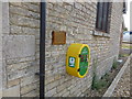
1
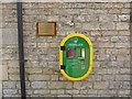
Defibrillator
On the wall at Image
The plaque reads
"This Defibrillator has kindly been donated by Mr & Mrs A Honeywood and Swinstead P.C."
Image: © Bob Harvey
Taken: 25 Jul 2019
0.03 miles
2
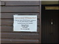
Next to the door
Contact details for the Village Hall
Image: © Bob Harvey
Taken: 25 Jul 2019
0.03 miles
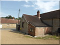
4
Defibrillator box at village hall
On the wall at Image
Image: © Bob Harvey
Taken: 25 Jul 2019
0.03 miles
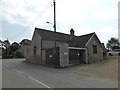
6
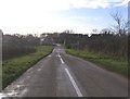
Approaching Swinstead from the northeast
Image: © Brian Green
Taken: 6 Jan 2008
0.04 miles