IMAGES TAKEN NEAR TO
Swinstead Road, GRANTHAM, NG33 4NU
Introduction
This page details the photographs taken nearby to Swinstead Road, NG33 4NU by members of the Geograph project.
The Geograph project started in 2005 with the aim of publishing, organising and preserving representative images for every square kilometre of Great Britain, Ireland and the Isle of Man.

There are currently over 7.5m images from over14,400 individuals and you can help contribute to the project by visiting https://www.geograph.org.uk
Image Map
Images are licensed for reuse under creativecommons.org/licenses/by-sa/2.0
Notes
- Clicking on the map will re-center to the selected point.
- The higher the marker number, the further away the image location is from the centre of the postcode.
Image Listing (156 Images Found)
Images are licensed for reuse under creativecommons.org/licenses/by-sa/2.0
Image
Details
Distance
1
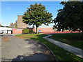
The Charles Read Academy
Built in 1963 as a 'Secondary Modern' school, and becoming a comprehensive after the 1965 Labour government attempted to end selection. In 1999 it was renamed the Charles Read High School,taking the name from the ancient grammar school in the village (Image)
It converted to an academy in January 2011 and was taken over by West Grantham Academies Trust. This body decided to close the school in 2013, raising many questions about how they had come to own the freehold, and after a considerable local storm control was passed to the Stamford-based David Ross Foundation instead of closing.
See http://www.stamfordmercury.co.uk/news/education/education-news/charles-read-academy-to-close-by-september-2014-1-4735778 and http://www.stamfordmercury.co.uk/news/education/education-news/charles-read-academy-saved-from-closure-by-trust-1-5181862
Image: © Bob Harvey
Taken: 24 Oct 2013
0.06 miles
2
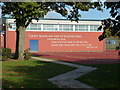
The writing on the wall
No, not "Mene, Mene, Tekel, Upharsin" but something far more straightforward. This is the uplifting motto on the outside of the sports hall at
Image]
Ken Venturi was a professional golfer, commentator, and charity fundraiser who died in May 2013
Image: © Bob Harvey
Taken: 24 Oct 2013
0.06 miles
5
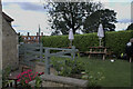
Outdoor dining
The Woodhouse Arms is a rather up-market establishment these days - a luxury restaurant. But the precautions introduced to cope with the Coronavirus pandemic meant it had to - rapidly - introduce outdoor dining, and here we see what is essentially an improvised outdoor restaurant with garden seating and umbrellas in a lawn. Although the regulations have been relaxed, people are still using this sort of arrangement, partly as a precaution and partly because we quite enjoy al fresco, now we have got used to doing it somewhere other than the Mediterranean.
Image: © Bob Harvey
Taken: 28 Aug 2021
0.10 miles
6
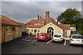
The Woodhouse Arms
This village pub has been extensively remodelled, and re-opened as a high class restaurant with modern bar. This is very welcome, as it had been closed for some time.
This view is of the new restaurant at the rear, and includes (on the left) the bed and breakfast apparments where the stable block once stood.
The new owners are young and enthusiastic, and the food is excellent. I hope they do well.
Image: © Bob Harvey
Taken: 10 Oct 2013
0.11 miles
7
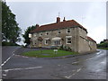
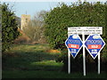
The Woodhouse Arms, Corby Glen
At the intersection of the A151 and B1176 roads.
Image: © JThomas
Taken: 12 Oct 2013
0.11 miles
8
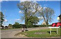
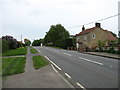
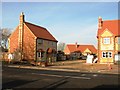
Station Road at the corner of Swinstead Road
Image: © David Howard
Taken: 7 May 2023
0.12 miles
10
Ecological house
This house features high levels of insulation and a turf roof.
Image: © Bob Harvey
Taken: 26 Sep 2014
0.13 miles