IMAGES TAKEN NEAR TO
Burton Lane, GRANTHAM, NG33 4JX
Introduction
This page details the photographs taken nearby to Burton Lane, NG33 4JX by members of the Geograph project.
The Geograph project started in 2005 with the aim of publishing, organising and preserving representative images for every square kilometre of Great Britain, Ireland and the Isle of Man.

There are currently over 7.5m images from over14,400 individuals and you can help contribute to the project by visiting https://www.geograph.org.uk
Image Map
Images are licensed for reuse under creativecommons.org/licenses/by-sa/2.0
Notes
- Clicking on the map will re-center to the selected point.
- The higher the marker number, the further away the image location is from the centre of the postcode.
Image Listing (8 Images Found)
Images are licensed for reuse under creativecommons.org/licenses/by-sa/2.0
Image
Details
Distance
1
Barley field near Dumpling Farm, Easton
Image: © Richard Humphrey
Taken: 12 Jul 2015
0.05 miles
2
Footpath and farmland near Dumpling Farm, Easton
Image: © Richard Humphrey
Taken: 12 Jul 2015
0.05 miles
3
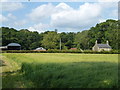
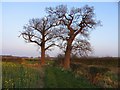
Dumpling Farm
A lovely name. Nestled into a corner of Pasture Holt wood, and conjuring images of a warm kitchen and hearty fare.
Image: © Tim Heaton
Taken: 19 Nov 2006
0.06 miles
4
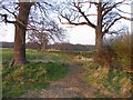
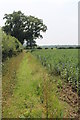
Footpath
This footpath runs from Ridd's Farm to Dumpling Farm which may be seen in the background.
Image: © Andrew Tatlow
Taken: 7 Apr 2007
0.14 miles
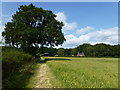
5
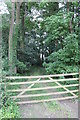
Footpath to Ridd's Farm
Off Burton Lane. The crops appear to be beans.
Image: © J.Hannan-Briggs
Taken: 14 Jul 2013
0.17 miles
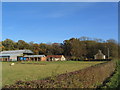
8
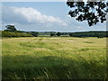
A sea of barley south of Dumpling Farm, Easton
Image: © Richard Humphrey
Taken: 12 Jul 2015
0.23 miles