IMAGES TAKEN NEAR TO
Little Humby, GRANTHAM, NG33 4HP
Introduction
This page details the photographs taken nearby to NG33 4HP by members of the Geograph project.
The Geograph project started in 2005 with the aim of publishing, organising and preserving representative images for every square kilometre of Great Britain, Ireland and the Isle of Man.

There are currently over 7.5m images from over14,400 individuals and you can help contribute to the project by visiting https://www.geograph.org.uk
Image Map
Images are licensed for reuse under creativecommons.org/licenses/by-sa/2.0
Notes
- Clicking on the map will re-center to the selected point.
- The higher the marker number, the further away the image location is from the centre of the postcode.
Image Listing (13 Images Found)
Images are licensed for reuse under creativecommons.org/licenses/by-sa/2.0
Image
Details
Distance
1
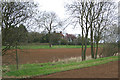
New England Cottage, near Humby, Lincolnshire
The only building in this square; peaceful isolation but only a short walk from the village.
Image: © Kate Jewell
Taken: 18 Apr 2006
0.01 miles
2
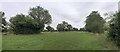
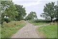
A small meadow
Bounded on the left by the road, and a stream on the right is this rectangular meadow.
Image: © Bob Harvey
Taken: 14 Aug 2024
0.07 miles
3
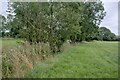
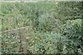
Weeds in the stream bed
The row of trees, and the tall vegetation in between them, mark the course of a small un-named stream, a tributary of the East Glen River.
Image: © Bob Harvey
Taken: 14 Aug 2024
0.07 miles
4
A poorly Ash
This ash tree, Fraxinus excelsior, like so many others, is putting up a fight against Ash die-back disease. The disease, caused by a fungus called Hymenoscyphus fraxineus, was first noticed in 2012 and is now widespread in the country. Older trees like this, are slightly less affected, although the leaf-less twigs at the extremity are typical of the disease. Ash seeds prolifically, and germinates like weeds. But those saplings are the most susceptible to the fungus and will rarely last a year out.
Image: © Bob Harvey
Taken: 14 Aug 2024
0.11 miles
5
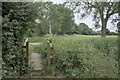
Culvert location
I was chasing the East Glen river, and this is a spot where one of the tributaries crosses this road. There is a culvert between the footpath sign on the left and the clump of bushes growing in the watercourse on the right.
Image: © Bob Harvey
Taken: 14 Aug 2024
0.11 miles
7
Hiddden culvert mouth
Somewhere in the middle of the image is the mouth of the culvert mentioned in Image It is obscured by vegetation.
Image: © Bob Harvey
Taken: 14 Aug 2024
0.12 miles
8
Footbridge
A drainage ditch runs at 90 degrees to the stream mentioned in Image This bridge lets the public footpath cross that drainage ditch - it is parallel to the line of the stream.
Image: © Bob Harvey
Taken: 14 Aug 2024
0.12 miles
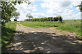
10

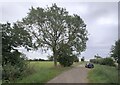
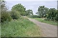
Track to Ingoldsby Wood
This section is a byway.
Image: © Jonathan Thacker
Taken: 18 Jul 2019
0.14 miles