IMAGES TAKEN NEAR TO
Hanby Road, GRANTHAM, NG33 4HD
Introduction
This page details the photographs taken nearby to Hanby Road, NG33 4HD by members of the Geograph project.
The Geograph project started in 2005 with the aim of publishing, organising and preserving representative images for every square kilometre of Great Britain, Ireland and the Isle of Man.

There are currently over 7.5m images from over14,400 individuals and you can help contribute to the project by visiting https://www.geograph.org.uk
Image Map
Images are licensed for reuse under creativecommons.org/licenses/by-sa/2.0
Notes
- Clicking on the map will re-center to the selected point.
- The higher the marker number, the further away the image location is from the centre of the postcode.
Image Listing (18 Images Found)
Images are licensed for reuse under creativecommons.org/licenses/by-sa/2.0
Image
Details
Distance
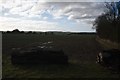
3

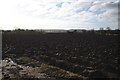
Flail-cut hedge
Flail cut hedge and standing water
Image: © Bob Harvey
Taken: 7 Jan 2018
0.05 miles
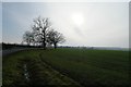
4

Wet hillside
This is a panorama stitched using Microsoft ICE from 30 separate images, yielding a view of 28535x9720 pixels, reduced to 12000x4088 to fit into Geograph. The larger version is available on demand
Image: © Bob Harvey
Taken: 7 Jan 2018
0.07 miles
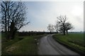
7
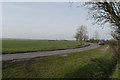
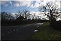
The road to Hanby
Between Lenton and Hanby
Image: © Richard Croft
Taken: 18 Jan 2011
0.14 miles