IMAGES TAKEN NEAR TO
NG33 4FE
Introduction
This page details the photographs taken nearby to NG33 4FE by members of the Geograph project.
The Geograph project started in 2005 with the aim of publishing, organising and preserving representative images for every square kilometre of Great Britain, Ireland and the Isle of Man.

There are currently over 7.5m images from over14,400 individuals and you can help contribute to the project by visiting https://www.geograph.org.uk
Image Map
Images are licensed for reuse under creativecommons.org/licenses/by-sa/2.0
Notes
- Clicking on the map will re-center to the selected point.
- The higher the marker number, the further away the image location is from the centre of the postcode.
Image Listing (12 Images Found)
Images are licensed for reuse under creativecommons.org/licenses/by-sa/2.0
Image
Details
Distance
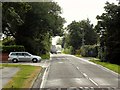
1
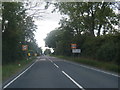
Bourne Road (A151)
Heading west into Corby Glen.
Image: © JThomas
Taken: 12 Oct 2013
0.10 miles
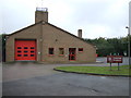
4
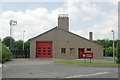
Corby Glen fire station
Corby Glen fire station, Bourne Road, Corby Glen, Lincolnshire
Image: © Kevin Hale
Taken: 31 May 2008
0.13 miles
7
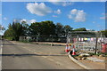
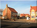
New road off Swinstead Road, Corby Glen
According to Google it's called Bish Close and will contain 66 new houses. https://allison-homes.co.uk/development/the-orchards/
Image: © David Howard
Taken: 7 May 2023
0.20 miles
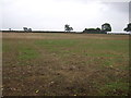
8
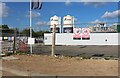
Building site by Swinstead Road, Corby Glen
This will be The Orchards, with the road from here going to meet Bourne Road. https://allison-homes.co.uk/development/the-orchards/
Image: © David Howard
Taken: 7 May 2023
0.20 miles