IMAGES TAKEN NEAR TO
Main Street, GRANTHAM, NG33 4ER
Introduction
This page details the photographs taken nearby to Main Street, NG33 4ER by members of the Geograph project.
The Geograph project started in 2005 with the aim of publishing, organising and preserving representative images for every square kilometre of Great Britain, Ireland and the Isle of Man.

There are currently over 7.5m images from over14,400 individuals and you can help contribute to the project by visiting https://www.geograph.org.uk
Image Map
Images are licensed for reuse under creativecommons.org/licenses/by-sa/2.0
Notes
- Clicking on the map will re-center to the selected point.
- The higher the marker number, the further away the image location is from the centre of the postcode.
Image Listing (74 Images Found)
Images are licensed for reuse under creativecommons.org/licenses/by-sa/2.0
Image
Details
Distance
1
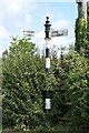
Old Direction Sign - Signpost by Main Street, Ingoldsby Parish
Ball finial - 3 arms; Coultas ball by the UC road, in parish of Ingoldsby (South Kesteven District), junction of Main Street with Grantham Road, by hedge.
Surveyed
Milestone Society National ID: LI_TF0030.
Image: © Milestone Society
Taken: Unknown
0.03 miles
2
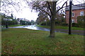
Rainy front passing through Ingoldsby
A cold front, passing through from the Northwest, brought hail and then cold rain through the village.
This is Grantham road.
Image: © Bob Harvey
Taken: 3 Nov 2013
0.04 miles
3
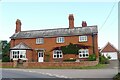
The Old Heathcote Arms, Ingoldsby
Originally built as farmer's cottages. It was converted to a pub by a member of the Heathcote family about 1811; then became an Everards pub; closed (when?), leaving the village 'dry'; and now produces honey https://theheathcotearms.co.uk/history https://www.heathcotehoney.co.uk/
Image: © Tim Heaton
Taken: 16 Sep 2021
0.05 miles
4
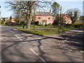
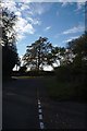
Road junction and grass triangle
Sunny March morning in Ingoldsby.
Image: © Michael Trolove
Taken: 26 Mar 2017
0.07 miles
5
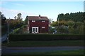
At the end of the day
Late in the day, a clearing sky backlights the trees in Ingoldsby
Image: © Bob Harvey
Taken: 20 Oct 2018
0.07 miles
7
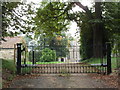
Entrance gates to Ingoldsby Manor House
Image: © Jonathan Thacker
Taken: 21 Sep 2016
0.09 miles
8
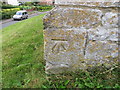
Ordnance Survey Cut Mark
This can be found on the wall of St Bartholomews Church, Ingoldsby.
For more detail see : http://www.bench-marks.org.uk/bm59264
Image: © Peter Wood
Taken: 19 Jul 2014
0.09 miles
9
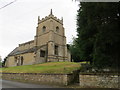
The Church of St Bartholomew at Ingoldsby
Viewed from the north-west.
Image: © Peter Wood
Taken: 19 Jul 2014
0.09 miles
10
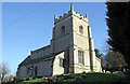
St Bartholomew's Church, Main Street, Ingoldsby
Grade I Parish Church. A church was recorded in Ingoldsby in the Domesday Book, which was probably a wooden building on the same site. As with many churches, dating back to the 12th century, this church has had many alterations and additions over the years. St Bartholomew's church was on Historic England's 'Heritage At Risk' Register and with help of a grant from the Lottery Fund and The National Churches Trust work started early in 2016 to replace the south aisle roof, works to the tower masonry and a damaged pinnacle, installation of lightning protection, installation of a toilet with remodelling of the vestry and the replacement of the fallen chancel gable end cross.
Image: © Jo and Steve Turner
Taken: 24 Mar 2017
0.09 miles