IMAGES TAKEN NEAR TO
Chapel Hill, GRANTHAM, NG33 4BP
Introduction
This page details the photographs taken nearby to Chapel Hill, NG33 4BP by members of the Geograph project.
The Geograph project started in 2005 with the aim of publishing, organising and preserving representative images for every square kilometre of Great Britain, Ireland and the Isle of Man.

There are currently over 7.5m images from over14,400 individuals and you can help contribute to the project by visiting https://www.geograph.org.uk
Image Map
Images are licensed for reuse under creativecommons.org/licenses/by-sa/2.0
Notes
- Clicking on the map will re-center to the selected point.
- The higher the marker number, the further away the image location is from the centre of the postcode.
Image Listing (121 Images Found)
Images are licensed for reuse under creativecommons.org/licenses/by-sa/2.0
Image
Details
Distance
1

A steep pit
Heavily overgrown with trees, it is hard to appreciate just how deep the excavation, and how precipitous the sides, at this former quarry
Image: © Bob Harvey
Taken: 31 Aug 2020
0.07 miles
4
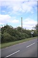
The Ropsley Stinkpipe
A concrete stink pipe stands by this road junction
- see http://parishes.lincolnshire.gov.uk/Files/Parish/742/Ropsley__District_Draft_Neighbourhood_Plan__Appendix_3_Heritage.pdf, which reckons it is rare. It stands above a steep disused quarry.
Image: © Bob Harvey
Taken: 31 Aug 2020
0.09 miles
5

Disguised quarry face
The roadside face of this disused quarry is sheer. and very deep indeed. Perhaps 20 metres.
Image: © Bob Harvey
Taken: 31 Aug 2020
0.09 miles
6
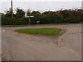
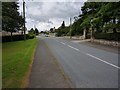
Road junction and grass triangle
Lightly eroded but surviving on the edge of Ropsley village.
Image: © Michael Trolove
Taken: 30 Oct 2016
0.10 miles
7
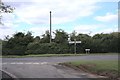
The Ropsley Stinkpipe
A concrete stink pipe stands by this road junction
- see http://parishes.lincolnshire.gov.uk/Files/Parish/742/Ropsley__District_Draft_Neighbourhood_Plan__Appendix_3_Heritage.pdf, which reckons it is rare. It stands above a steep disused quarry.
Image: © Bob Harvey
Taken: 31 Aug 2020
0.10 miles
8
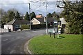
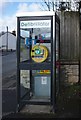
Corner of Paddock Close
The Telephone box has been turned into a Defibrillator station
Image: © Bob Harvey
Taken: 10 Mar 2019
0.10 miles