IMAGES TAKEN NEAR TO
Bracton Drive, NOTTINGHAM, NG3 2LN
Introduction
This page details the photographs taken nearby to Bracton Drive, NG3 2LN by members of the Geograph project.
The Geograph project started in 2005 with the aim of publishing, organising and preserving representative images for every square kilometre of Great Britain, Ireland and the Isle of Man.

There are currently over 7.5m images from over14,400 individuals and you can help contribute to the project by visiting https://www.geograph.org.uk
Image Map
Images are licensed for reuse under creativecommons.org/licenses/by-sa/2.0
Notes
- Clicking on the map will re-center to the selected point.
- The higher the marker number, the further away the image location is from the centre of the postcode.
Image Listing (15 Images Found)
Images are licensed for reuse under creativecommons.org/licenses/by-sa/2.0
Image
Details
Distance
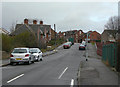
1
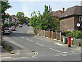
Alma Road
A quiet suburban street off Carlton Road.
Image: © Alan Murray-Rust
Taken: 29 May 2008
0.14 miles
2
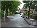
Serlby Rise
Inter-war council housing development off Carlton Road.
Image: © Alan Murray-Rust
Taken: 19 May 2009
0.18 miles
3
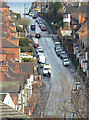
Donkey Hill
Officially St bartholomew's Road, it's always known locally by its nickname, although where this originates I do not know. The gradient is probably about 1 in 7.
Image: © Alan Murray-Rust
Taken: 8 Mar 2009
0.19 miles
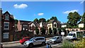
4
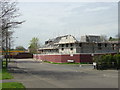
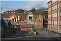
Farewell to The Jubilee
The Jubilee, formerly The Marmion, was a rather unattractive 1960s built pub. In later years it had a poor reputation which basically resulted in its closure. After 2-3 years of dereliction it was demolished to make way for the new housing seen being built in this view.
Image: © Alan Murray-Rust
Taken: 27 Apr 2008
0.19 miles
5
Blue Bell Hill Road
This point is where the 1970s redevelopment of St Anns stopped, and existing buildings stayed in place. However, even the terraced houses at the top of the hill would have been superior to the bulk of those replaced, and worth retaining.
Image: © Alan Murray-Rust
Taken: 8 Mar 2009
0.20 miles
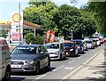
6
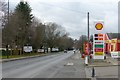
Carlton Road with hardly a car in sight
Christmas Day, but even so the filling station is open for business.
Image: © Alan Murray-Rust
Taken: 25 Dec 2017
0.22 miles
9
Hindu Temple, Carlton Road
A converted Victorian school
Image: © Alan Murray-Rust
Taken: 11 Feb 2007
0.24 miles
10
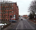
Nottingham, NG3 - Carlton Rd
A view of Carlton Road (the B686) looking towards the city centre. The grey car on the left is waiting to pull out of Hooton Lane and the metallic silver/grey car on the right is hovering on the Linnell Street junction, opposite this prominent former Victorian mill.
Image: © David Hallam-Jones
Taken: 24 Jan 2013
0.24 miles