IMAGES TAKEN NEAR TO
Edginton Terrace, NOTTINGHAM, NG3 2LJ
Introduction
This page details the photographs taken nearby to Edginton Terrace, NG3 2LJ by members of the Geograph project.
The Geograph project started in 2005 with the aim of publishing, organising and preserving representative images for every square kilometre of Great Britain, Ireland and the Isle of Man.

There are currently over 7.5m images from over14,400 individuals and you can help contribute to the project by visiting https://www.geograph.org.uk
Image Map
Images are licensed for reuse under creativecommons.org/licenses/by-sa/2.0
Notes
- Clicking on the map will re-center to the selected point.
- The higher the marker number, the further away the image location is from the centre of the postcode.
Image Listing (23 Images Found)
Images are licensed for reuse under creativecommons.org/licenses/by-sa/2.0
Image
Details
Distance
1
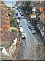
Donkey Hill
Officially St bartholomew's Road, it's always known locally by its nickname, although where this originates I do not know. The gradient is probably about 1 in 7.
Image: © Alan Murray-Rust
Taken: 8 Mar 2009
0.12 miles
2
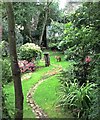
The Visitor
Urban Garden, Thorney Hill, Nottingham
Image: © Sarah Walton
Taken: 24 Jul 2017
0.13 miles

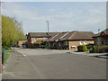
4
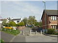
Marmion Road (north end)
The road has been blocked to prevent its use as a rat run, but the presence of different styles of post show that in practice the barrier has been breached from time to time.
Image: © Alan Murray-Rust
Taken: 27 Apr 2008
0.18 miles
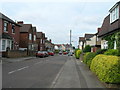
7
Marmion Road (south end)
The modern housing has been built on the site of the old Thorneywood Station.
Image: © Alan Murray-Rust
Taken: 27 Apr 2008
0.19 miles
8
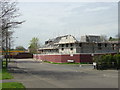
Farewell to The Jubilee
The Jubilee, formerly The Marmion, was a rather unattractive 1960s built pub. In later years it had a poor reputation which basically resulted in its closure. After 2-3 years of dereliction it was demolished to make way for the new housing seen being built in this view.
Image: © Alan Murray-Rust
Taken: 27 Apr 2008
0.20 miles
9
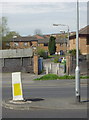
Former footbridge location
The dark engineering brick wall formerly marked the edge of the area of Thorneywood Station. This lay in a cutting well below the road and was crossed by a lattice metal footbridge which lasted for years after the station and railway closed. The cutting was for a long time a Post Office Telephones maintenance depot, but has since been filled in converted for housing use.
Image: © Alan Murray-Rust
Taken: 27 Apr 2008
0.20 miles
10
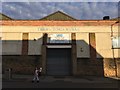
The V ctoria Works
The Wells Road, St Ann's
Image: © David Lally
Taken: 12 Aug 2017
0.21 miles