IMAGES TAKEN NEAR TO
Carlton Road, NOTTINGHAM, NG3 2AS
Introduction
This page details the photographs taken nearby to Carlton Road, NG3 2AS by members of the Geograph project.
The Geograph project started in 2005 with the aim of publishing, organising and preserving representative images for every square kilometre of Great Britain, Ireland and the Isle of Man.

There are currently over 7.5m images from over14,400 individuals and you can help contribute to the project by visiting https://www.geograph.org.uk
Image Map
Images are licensed for reuse under creativecommons.org/licenses/by-sa/2.0
Notes
- Clicking on the map will re-center to the selected point.
- The higher the marker number, the further away the image location is from the centre of the postcode.
Image Listing (69 Images Found)
Images are licensed for reuse under creativecommons.org/licenses/by-sa/2.0
Image
Details
Distance
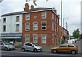
1
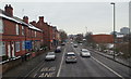
Nottingham, NG3 - Carlton Road
The edge of the city centre is seen in the distance in this view of Carlton Road (the B686). The pillar box on the left is situated at the junction of Denstone Road.
Image: © David Hallam-Jones
Taken: 24 Jan 2013
0.02 miles
2
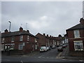
St. Cuthbert's Road
A short street linking Carlton Road with Spalding Road.
Image: © Jonathan Thacker
Taken: 9 Jul 2018
0.04 miles
3
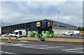
Lidl supermarket, Carlton Road
Due to open 2 days after this picture was taken. It is on the site of the former Wright and Dobson dye works, which was demolished in 2002.
Image: © Alan Murray-Rust
Taken: 23 May 2017
0.04 miles
5
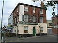
The former Duke of Cambridge public house
This closed around 2013 and was converted quite quickly into student flats. There's nothing now that really indicates its original use. The building dates from 1878.
Image: © Alan Murray-Rust
Taken: 23 May 2017
0.08 miles
6
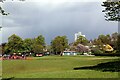
A view across King Edward Park
Sun in the foreground but wintry showers around.
Image: © Alan Murray-Rust
Taken: 6 May 2021
0.08 miles
7
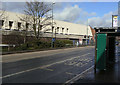
Closed superstore
When it opened, around 1980, this Cooperative superstore was very much a flagship. However, the location was never really ideal, and it never seemed to be particularly busy, and it finally closed just a few weeks before this picture was taken.
Image: © Alan Murray-Rust
Taken: 8 Mar 2009
0.09 miles
8
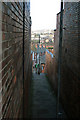
Stairway from Windmill Lane to Spalding Street, Sneinton
Image: © Alan Murray-Rust
Taken: 11 Feb 2007
0.09 miles
9
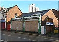
Former Co-op
Roundels on the white panels of the pillars have the monogram NCS, but even without them this frontage has all the hallmarks of having been a Co-op store. It ceased to be one when the superstore Image on the opposite side of the road was opened, and has since had a variety of occupants, that last one being a charity. It has been unoccupied for some months now and I feel it unlikely that either it or its successor will find new occupants.
Image: © Alan Murray-Rust
Taken: 8 Mar 2009
0.10 miles
10
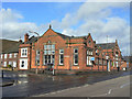
Carlton Road Library
One of the series of suburban libraries built by Nottingham Corporation at the end of the 19th century.
Image: © Alan Murray-Rust
Taken: 8 Mar 2009
0.11 miles