IMAGES TAKEN NEAR TO
Dakeyne Street, NOTTINGHAM, NG3 2AR
Introduction
This page details the photographs taken nearby to Dakeyne Street, NG3 2AR by members of the Geograph project.
The Geograph project started in 2005 with the aim of publishing, organising and preserving representative images for every square kilometre of Great Britain, Ireland and the Isle of Man.

There are currently over 7.5m images from over14,400 individuals and you can help contribute to the project by visiting https://www.geograph.org.uk
Image Map
Images are licensed for reuse under creativecommons.org/licenses/by-sa/2.0
Notes
- Clicking on the map will re-center to the selected point.
- The higher the marker number, the further away the image location is from the centre of the postcode.
Image Listing (261 Images Found)
Images are licensed for reuse under creativecommons.org/licenses/by-sa/2.0
Image
Details
Distance
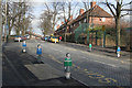
1
Nottingham - NG3 (Sneinton)
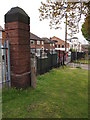
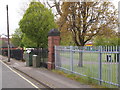
This gate post at the edge of King Edward Park, off Dakeyne Street, is all that remains of The General Lunatic Asylum for the Town & County of Nottingham. In 1873, once all its private patients had been transferred to The Coppice Hospital, Mapperley it became known as The County Lunatic Asylum. This was in turn replaced by Saxondale Hospital that served residents of Notts from 1902-88. During the late 50s and the 60s at least part of the Sneinton buildings were used by the Dakeyn Street Lads' Club (later to become The Oliver Hind Boys Brigade).
Image: © David Hallam-Jones
Taken: 5 May 2012
0.01 miles
2
Nottingham - NG3 (Sneinton)
This gate post at the edge of King Edward Park off Dakeyne Street is all that remains of The General Lunatic Asylum for the Town & County of Nottingham. In 1873, once all its private patients had been transferred to The Coppice Hospital, Mapperley it became known as The County Lunatic Asylum. This was in turn replaced by Saxondale Hospital that served residents of Notts from 1902-88. During the late 50s and the 60s at least part of the Sneinton buildings were used by the Dakeyn Street Lads' Club (later to become The Oliver Hind Boys Brigade).
Image: © David Hallam-Jones
Taken: 5 May 2012
0.01 miles
3
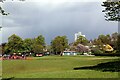
A view across King Edward Park
Sun in the foreground but wintry showers around.
Image: © Alan Murray-Rust
Taken: 6 May 2021
0.06 miles
4
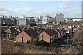
View from Windmill Lane
Looking across to Nottingham City Centre. The dome of the Council House can be seen to the left of the picture.
Image: © Alan Murray-Rust
Taken: 11 Feb 2007
0.06 miles
5
Windmill Lane at Sneinton Primary School.
Colourful figurines are bollards to deter motorists parking on the footway when collecting children. Most of them have a name written in felt pen on their foreheads. The two nearest are Sarah and Jack!
Image: © Alan Murray-Rust
Taken: 11 Feb 2007
0.08 miles
6
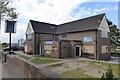
The Queen Adelaide
Closed since the last time I was here Image
Image: © David Lally
Taken: 25 Apr 2017
0.09 miles
7
The former Queen Alexandra pub
Now being converted into apartments.
Image: © Jonathan Thacker
Taken: 5 Jun 2018
0.09 miles
8
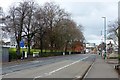
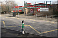
Carlton Road, Christmas Day
Probably the only day of the year when you will see it as empty as this in the middle of the day – just one solitary car in sight.
Image: © Alan Murray-Rust
Taken: 25 Dec 2017
0.09 miles
9
Sneinton Primary School, Windmill Lane
The small figure is a bollard to prevent parking on the footway!
Image: © Alan Murray-Rust
Taken: 11 Feb 2007
0.09 miles
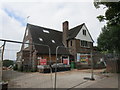
10
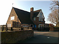
The Queen Adelaide
On Windmill Lane, Sneinton.
Almost certainly this was built as a Hardy Hansons (Kimberley's) http://en.wikipedia.org/wiki/Kimberley_Brewery pub.
Image: © David Lally
Taken: 19 Apr 2009
0.09 miles