1
Carlton Road Library
One of the series of suburban libraries built by Nottingham Corporation at the end of the 19th century.
Image: © Alan Murray-Rust
Taken: 8 Mar 2009
0.01 miles
2
Carlton Road Library
Nottingham had a very progressive approach to library provision with a number of quite substantial suburban locations at the end of the 19th century, many of which survive in use. In most cases the space is now used to provide ancillary book storage alongside the continuing lending facilities.
Image: © Alan Murray-Rust
Taken: 27 Apr 2008
0.01 miles
3
Church of St Mathias
Small gothic-style church from 1867, it is now out of use and it looks as if interior demolition may already be under way.
Image: © Alan Murray-Rust
Taken: 8 Mar 2009
0.03 miles
4
Closed superstore
When it opened, around 1980, this Cooperative superstore was very much a flagship. However, the location was never really ideal, and it never seemed to be particularly busy, and it finally closed just a few weeks before this picture was taken.
Image: © Alan Murray-Rust
Taken: 8 Mar 2009
0.04 miles
5
Former Co-op
Roundels on the white panels of the pillars have the monogram NCS, but even without them this frontage has all the hallmarks of having been a Co-op store. It ceased to be one when the superstore
Image on the opposite side of the road was opened, and has since had a variety of occupants, that last one being a charity. It has been unoccupied for some months now and I feel it unlikely that either it or its successor will find new occupants.
Image: © Alan Murray-Rust
Taken: 8 Mar 2009
0.04 miles
6
St. Matthias' Church, Sneinton
Just after closure.
Image: © Andrew Abbott
Taken: 6 Sep 2008
0.04 miles
7
Nottingham NG3 Carlton Rd (Lower End)
The lower part of St Mathias’ Road (once known as Element Hill), with Carlton Road (the B686 road) in the distance. The former St Mathias' Anglican Church was closed in 2003 and the building eventually became the home of the Coptic Orthodox Church of St Mary & St George in March 2009. St. Matthias' Anglican Church was originally consecrated in 1867.
Image: © David Hallam-Jones
Taken: 24 Jan 2013
0.05 miles
8
St. Cuthbert's Road
A short street linking Carlton Road with Spalding Road.
Image: © Jonathan Thacker
Taken: 9 Jul 2018
0.08 miles
9
Nottingham, NG3 - St Ann's
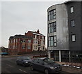
A view of the former Lord Alcester pub near the top of St Mathias' Road as seen from Woodhouse Street. The metallic bow-edged building is part of an apartment complex called Albany House, that hosts a community cafe. The pub was built in the 1950s but was extended and converted into nine self-contained flats in 2012.
Image: © David Hallam-Jones
Taken: 24 Jan 2013
0.10 miles
10
Nottingham, NG3 - Carlton Road
The edge of the city centre is seen in the distance in this view of Carlton Road (the B686). The pillar box on the left is situated at the junction of Denstone Road.
Image: © David Hallam-Jones
Taken: 24 Jan 2013
0.10 miles


