IMAGES TAKEN NEAR TO
West Willoughby, GRANTHAM, NG32 3SL
Introduction
This page details the photographs taken nearby to NG32 3SL by members of the Geograph project.
The Geograph project started in 2005 with the aim of publishing, organising and preserving representative images for every square kilometre of Great Britain, Ireland and the Isle of Man.

There are currently over 7.5m images from over14,400 individuals and you can help contribute to the project by visiting https://www.geograph.org.uk
Image Map
Images are licensed for reuse under creativecommons.org/licenses/by-sa/2.0
Notes
- Clicking on the map will re-center to the selected point.
- The higher the marker number, the further away the image location is from the centre of the postcode.
Image Listing (7 Images Found)
Images are licensed for reuse under creativecommons.org/licenses/by-sa/2.0
Image
Details
Distance
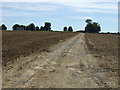
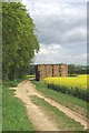
1
Willoughby Grange & Byway
Heath lane is a restricted byway not open to motor traffic.
Image: © Glyn Baker
Taken: 13 May 2012
0.03 miles
2
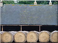
Willoughby Grange Straw Wall
Neatly lined up bales run alongside the buildings, presumably to keep prying eyes at bay.
Image: © Ian Paterson
Taken: 15 Jun 2007
0.05 miles
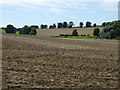
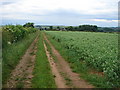
3
Heath Lane Near Willoughby Grange
Straw bales beside the byway
Image: © Glyn Baker
Taken: 13 May 2012
0.07 miles
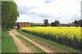
5
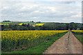
Towards West Willoughby
Looking towards the end of Heath Lane
Image: © Glyn Baker
Taken: 13 May 2012
0.18 miles