IMAGES TAKEN NEAR TO
West Willoughby, GRANTHAM, NG32 3SJ
Introduction
This page details the photographs taken nearby to NG32 3SJ by members of the Geograph project.
The Geograph project started in 2005 with the aim of publishing, organising and preserving representative images for every square kilometre of Great Britain, Ireland and the Isle of Man.

There are currently over 7.5m images from over14,400 individuals and you can help contribute to the project by visiting https://www.geograph.org.uk
Image Map
Images are licensed for reuse under creativecommons.org/licenses/by-sa/2.0
Notes
- Clicking on the map will re-center to the selected point.
- The higher the marker number, the further away the image location is from the centre of the postcode.
Image Listing (3 Images Found)
Images are licensed for reuse under creativecommons.org/licenses/by-sa/2.0
Image
Details
Distance
1
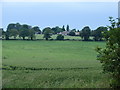
High Field House in the distance
Looking across the fields from the public footpath
Image: © Ian Paterson
Taken: 15 Jun 2007
0.13 miles
2
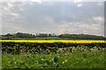
View south from the A153 - West Willoughby
Image: © Mick Lobb
Taken: 18 May 2010
0.23 miles
3
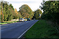
A153, Sleaford Road at West Willoughby
Looking towards Ancaster.
Image: © Kate Jewell
Taken: 29 Oct 2006
0.25 miles