IMAGES TAKEN NEAR TO
Carlton Road, GRANTHAM, NG32 3SG
Introduction
This page details the photographs taken nearby to Carlton Road, NG32 3SG by members of the Geograph project.
The Geograph project started in 2005 with the aim of publishing, organising and preserving representative images for every square kilometre of Great Britain, Ireland and the Isle of Man.

There are currently over 7.5m images from over14,400 individuals and you can help contribute to the project by visiting https://www.geograph.org.uk
Image Map
Images are licensed for reuse under creativecommons.org/licenses/by-sa/2.0
Notes
- Clicking on the map will re-center to the selected point.
- The higher the marker number, the further away the image location is from the centre of the postcode.
Image Listing (4 Images Found)
Images are licensed for reuse under creativecommons.org/licenses/by-sa/2.0
Image
Details
Distance
2
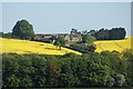
Sudbrook Hill Farm, viewed from West Willoughby
Surrounded by fields of oil seed rape, the farm sits in a small valley cutting into the scarp of the Lincoln Edge, just west of the village of Sudbrook.
Image: © Simon Mortimer
Taken: 1 May 2011
0.01 miles