IMAGES TAKEN NEAR TO
Carlton Road, GRANTHAM, NG32 3SF
Introduction
This page details the photographs taken nearby to Carlton Road, NG32 3SF by members of the Geograph project.
The Geograph project started in 2005 with the aim of publishing, organising and preserving representative images for every square kilometre of Great Britain, Ireland and the Isle of Man.

There are currently over 7.5m images from over14,400 individuals and you can help contribute to the project by visiting https://www.geograph.org.uk
Image Map
Images are licensed for reuse under creativecommons.org/licenses/by-sa/2.0
Notes
- Clicking on the map will re-center to the selected point.
- The higher the marker number, the further away the image location is from the centre of the postcode.
Image Listing (7 Images Found)
Images are licensed for reuse under creativecommons.org/licenses/by-sa/2.0
Image
Details
Distance
1
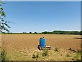
Blue drum barrel in the corner of a field
The drum was empty. After a long spell of dry weather the very small, newly emerging wheat plants could certainly benefit from some water.
Image: © Tim Heaton
Taken: 16 Jun 2023
0.17 miles
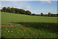
3
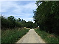
Heath Lane heading north from Sudbrook
Byway rising up to the Lincolnshire Limestone escarpment at the north edge of the Ancaster Gap
Image: © Tim Heaton
Taken: 16 Jun 2023
0.19 miles
4
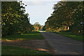
Carlton Road, Sudbrook
Looking from the entrance to Sudbrook Hill Farm towards Sudbrook village.
Image: © Kate Jewell
Taken: 29 Oct 2006
0.21 miles
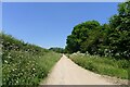
6
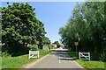
Carlton Road entering Sudbrook
Sudbrook = southern brook https://www.oxfordreference.com/display/10.1093/acref/9780199609086.001.0001/acref-9780199609086-e-12534?rskey=ZPbO42&result=12681
Image: © Tim Heaton
Taken: 16 Jun 2023
0.23 miles