IMAGES TAKEN NEAR TO
Sudbrook Heath, GRANTHAM, NG32 3RJ
Introduction
This page details the photographs taken nearby to Sudbrook Heath, NG32 3RJ by members of the Geograph project.
The Geograph project started in 2005 with the aim of publishing, organising and preserving representative images for every square kilometre of Great Britain, Ireland and the Isle of Man.

There are currently over 7.5m images from over14,400 individuals and you can help contribute to the project by visiting https://www.geograph.org.uk
Image Map
Images are licensed for reuse under creativecommons.org/licenses/by-sa/2.0
Notes
- Clicking on the map will re-center to the selected point.
- The higher the marker number, the further away the image location is from the centre of the postcode.
Image Listing (18 Images Found)
Images are licensed for reuse under creativecommons.org/licenses/by-sa/2.0
Image
Details
Distance
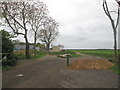
1
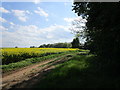
Farm track and oilseed rape by The Cottages
Image: © Jonathan Thacker
Taken: 12 May 2019
0.01 miles
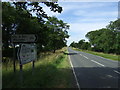
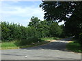
3
Church Lane
Church Lane approaching junction with High Dike (B6403)
Image: © Shaun Ferguson
Taken: 12 Oct 2009
0.05 miles
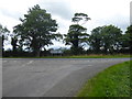
5

Church Lane junction with the B6403
Left for Ancaster.
Image: © Julian P Guffogg
Taken: 14 Jun 2015
0.06 miles
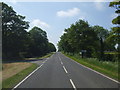
6
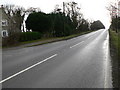
Looking across Ermine Street
Ermine Street was the Roman road which ran from London to Lincoln and York. This is the view from Church Lane, the church in question being North Rauceby.
Image: © Marathon
Taken: 12 Aug 2017
0.06 miles
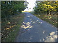
9
Ermine Street Roman Road
Looking S from the Church Lane junction
Image: © Ian Carrington
Taken: 26 Dec 2005
0.09 miles