IMAGES TAKEN NEAR TO
Waterwell Lane, GRANTHAM, NG32 3RG
Introduction
This page details the photographs taken nearby to Waterwell Lane, NG32 3RG by members of the Geograph project.
The Geograph project started in 2005 with the aim of publishing, organising and preserving representative images for every square kilometre of Great Britain, Ireland and the Isle of Man.

There are currently over 7.5m images from over14,400 individuals and you can help contribute to the project by visiting https://www.geograph.org.uk
Image Map
Images are licensed for reuse under creativecommons.org/licenses/by-sa/2.0
Notes
- Clicking on the map will re-center to the selected point.
- The higher the marker number, the further away the image location is from the centre of the postcode.
Image Listing (5 Images Found)
Images are licensed for reuse under creativecommons.org/licenses/by-sa/2.0
Image
Details
Distance
2
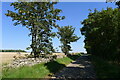
Waterwell Lane
Remnants of a Lincolnshire Limestone dry stone wall bound long sections of the north side of the lane.
Image: © Tim Heaton
Taken: 4 Sep 2023
0.14 miles
3
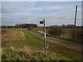
Quiet lane
Along this road dog walkers panic when a car approaches
Image: © Ken Brockway
Taken: 10 Mar 2007
0.17 miles
4
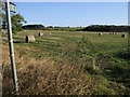
Footpath off Waterwell Lane
Footpath to Church Lane heading off Waterwell Lane
Image: © Shaun Ferguson
Taken: 12 Oct 2009
0.24 miles
5
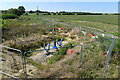
Water pipeline equipment, Waterwell Lane
Some sort of gate valve? set on Anglian Water's new Lincoln to Ancaster Pipeline; part of their strategy to manage water distribution over a very dry part of the country https://planning.southkesteven.gov.uk/SKDC/S20-1907/1879442.pdf
Image: © Tim Heaton
Taken: 4 Sep 2023
0.24 miles