IMAGES TAKEN NEAR TO
Ermine Street, GRANTHAM, NG32 3QL
Introduction
This page details the photographs taken nearby to Ermine Street, NG32 3QL by members of the Geograph project.
The Geograph project started in 2005 with the aim of publishing, organising and preserving representative images for every square kilometre of Great Britain, Ireland and the Isle of Man.

There are currently over 7.5m images from over14,400 individuals and you can help contribute to the project by visiting https://www.geograph.org.uk
Image Map
Images are licensed for reuse under creativecommons.org/licenses/by-sa/2.0
Notes
- Clicking on the map will re-center to the selected point.
- The higher the marker number, the further away the image location is from the centre of the postcode.
Image Listing (42 Images Found)
Images are licensed for reuse under creativecommons.org/licenses/by-sa/2.0
Image
Details
Distance
1
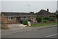
Bungalow on Ermine Street
This bungalow was displaying one of the few bits of referendum material I have seen in Lincolnshire
Image: © Bob Harvey
Taken: 23 Jun 2016
0.05 miles
2
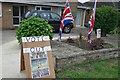
Home Made propaganda
With handwritten notes, a newspaper front page, and some flags this householder left me in no doubt of his political views.
See Image for the bungalow itself
Image: © Bob Harvey
Taken: 23 Jun 2016
0.05 miles
3
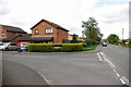
Ermine St & Meadowbrook
Ancaster is clearly not fossilised in its past. New development is still taking place keep it as a living community.
Image: © Glyn Baker
Taken: 13 May 2012
0.07 miles
4
Post Office on Ermine St
Ancaster Post Office stands on one of the oldest communication routes in the country
Image: © Glyn Baker
Taken: 13 May 2012
0.11 miles
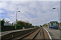
5
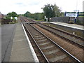
Ancaster station
Ancaster station was opened on 16th June 1857 by the Boston, Sleaford & Midland Counties Railway. Trains now run to Nottingham in one direction and Skegness in the other. This is the platform for Skegness bound trains.
Image: © Marathon
Taken: 12 Aug 2017
0.11 miles
6
Ancaster Railway Station
Ancaster Railway Station on the Nottingham to Skegness line
Image: © Shaun Ferguson
Taken: 12 Oct 2009
0.12 miles
7
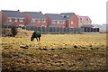
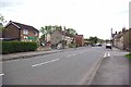
Horse grazing on the edge of Ancaster
New housing developments and pony paddocks compete for land on the edge of the village. The houses are part of the Charlestown development.
Image: © Simon Mortimer
Taken: 1 Jan 2009
0.12 miles
8
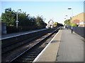
Ancaster station
Ancaster station was opened on 16th June 1857 by the Boston, Sleaford & Midland Counties Railway. Trains now run to Nottingham in one direction and Skegness in the other. In this photograph a Skegness bound train has just passed through the station without stopping.
Image: © Marathon
Taken: 12 Aug 2017
0.12 miles
9
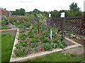
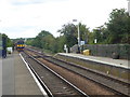
The station garden at Ancaster
Ancaster station was opened on 16th June 1857 by the Boston, Sleaford & Midland Counties Railway. Trains now run to Nottingham in one direction and Skegness in the other. The station garden is next to the Skegness bound platform. The signal box is still operational - see http://www.geograph.org.uk/photo/5498279
Image: © Marathon
Taken: 12 Aug 2017
0.12 miles
10
Ancaster station
On the Nottingham-Grantham-Skegness line
Image: © Tim Heaton
Taken: 28 Sep 2022
0.13 miles