IMAGES TAKEN NEAR TO
Ermine Street, GRANTHAM, NG32 3PY
Introduction
This page details the photographs taken nearby to Ermine Street, NG32 3PY by members of the Geograph project.
The Geograph project started in 2005 with the aim of publishing, organising and preserving representative images for every square kilometre of Great Britain, Ireland and the Isle of Man.

There are currently over 7.5m images from over14,400 individuals and you can help contribute to the project by visiting https://www.geograph.org.uk
Image Map
Images are licensed for reuse under creativecommons.org/licenses/by-sa/2.0
Notes
- Clicking on the map will re-center to the selected point.
- The higher the marker number, the further away the image location is from the centre of the postcode.
Image Listing (7 Images Found)
Images are licensed for reuse under creativecommons.org/licenses/by-sa/2.0
Image
Details
Distance
1
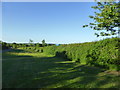
Verge of the Roman Road
This part of the verge is mown by a homeowner, who has also put an election poster up.
Image: © Bob Harvey
Taken: 26 May 2017
0.06 miles

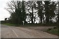
3
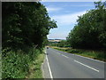
High Dike (B6403) heading north towards Ancaster
Image: © JThomas
Taken: 9 Aug 2012
0.09 miles
6
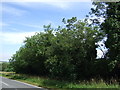
Copper Hill roadside verge nature reserve
See http://www.lincstrust.org.uk/reserves/dukes-covert-copper-hill
Image: © Chris
Taken: 14 Apr 2018
0.18 miles
7
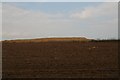
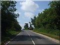
Sandy soil and limestone quarry spoil viewed from Ancaster Valley side
One of many limestone quarries near Ancaster.
The area has been quarried for thousands of years and yields an oolitic limestone varying in colour from white/beige to grey. For further details see one local quarry's website: http://www.goldholme.com/stone.html
Image: © Chris
Taken: 14 Apr 2018
0.19 miles