IMAGES TAKEN NEAR TO
Hillside, GRANTHAM, NG32 3PX
Introduction
This page details the photographs taken nearby to Hillside, NG32 3PX by members of the Geograph project.
The Geograph project started in 2005 with the aim of publishing, organising and preserving representative images for every square kilometre of Great Britain, Ireland and the Isle of Man.

There are currently over 7.5m images from over14,400 individuals and you can help contribute to the project by visiting https://www.geograph.org.uk
Image Map
Images are licensed for reuse under creativecommons.org/licenses/by-sa/2.0
Notes
- Clicking on the map will re-center to the selected point.
- The higher the marker number, the further away the image location is from the centre of the postcode.
Image Listing (19 Images Found)
Images are licensed for reuse under creativecommons.org/licenses/by-sa/2.0
Image
Details
Distance
1
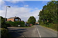
Wilsford Lane at the junction with Roman Way, Ancaster
Roman Way leads to the fields on the south side of Ancaster where the small Roman town was sited. There is little to see now.
Image: © Tim Heaton
Taken: 28 Sep 2022
0.11 miles
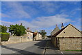
2

Ancaster Telephone Exchange, Lincs
Situated in Willsford Lane, this modern redbrick building would have replaced a smaller building from the GPO era in the same village some years ago. It has the code EMANCAS and provides telephone and broadband services to 899 residential and 46 non-residential premises in Ancaster plus Kelby, Sudbrook, Welby, West Willoughby and Wilsford nearby. A square white BT warning notice can be seen on the front of this building. The numbering ranges of this TE are (01400) 230xxx, 231xxx, the (01400) referring to the Honington (Lincs) group of five TEs, and its postcode is NG32 3PS.
Image: © David Hillas
Taken: 15 Jul 2019
0.14 miles
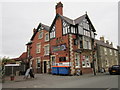
4
Post Office on Ermine St
Ancaster Post Office stands on one of the oldest communication routes in the country
Image: © Glyn Baker
Taken: 13 May 2012
0.19 miles
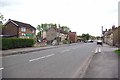
5
Ermine Street at Ancaster
Looking back towards the Sleaford Dr
Image: © Glyn Baker
Taken: 13 May 2012
0.19 miles
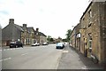
6
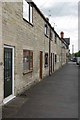
An Ermine St Terrace Ancaster
Solid stone built cottages in Ancaster.
Image: © Glyn Baker
Taken: 13 May 2012
0.19 miles
7
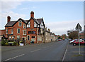
The Ermine, Main Street
Built in 1898, the pub takes its name from the Roman road which forms the main road through the village.
Image: © Alan Murray-Rust
Taken: 19 Nov 2014
0.19 miles
8

Ancaster Village Hall
Built in 1900 as a Masonic lodge, this is now the village hall.
See Image for the datestone above the porch
Image: © Bob Harvey
Taken: 23 Feb 2019
0.20 miles
9
Ancaster
The village lines the old Roman road, Ermine Street.
Image: © Tim Heaton
Taken: 28 Sep 2022
0.20 miles
