IMAGES TAKEN NEAR TO
Wilsford, GRANTHAM, NG32 3NZ
Introduction
This page details the photographs taken nearby to NG32 3NZ by members of the Geograph project.
The Geograph project started in 2005 with the aim of publishing, organising and preserving representative images for every square kilometre of Great Britain, Ireland and the Isle of Man.

There are currently over 7.5m images from over14,400 individuals and you can help contribute to the project by visiting https://www.geograph.org.uk
Image Map
Images are licensed for reuse under creativecommons.org/licenses/by-sa/2.0
Notes
- Clicking on the map will re-center to the selected point.
- The higher the marker number, the further away the image location is from the centre of the postcode.
Image Listing (3 Images Found)
Images are licensed for reuse under creativecommons.org/licenses/by-sa/2.0
Image
Details
Distance
1
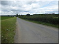
Access road to Waterloo Farm
This is looking from the A153 between Wilsford and Ancaster where it is known here as Town End.
Image: © Marathon
Taken: 12 Aug 2017
0.13 miles
2
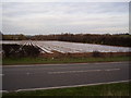
In hope of an early crop!
From a distance these plastic covered fields can look like an expanse of water
Image: © Ken Brockway
Taken: 10 Mar 2007
0.18 miles
3
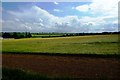
3 Stripes
Fields and sky near to Waterloo Farm, Ancaster
Image: © Donnylad
Taken: 23 Jun 2007
0.20 miles