IMAGES TAKEN NEAR TO
Aisby, GRANTHAM, NG32 3NE
Introduction
This page details the photographs taken nearby to NG32 3NE by members of the Geograph project.
The Geograph project started in 2005 with the aim of publishing, organising and preserving representative images for every square kilometre of Great Britain, Ireland and the Isle of Man.

There are currently over 7.5m images from over14,400 individuals and you can help contribute to the project by visiting https://www.geograph.org.uk
Image Map
Images are licensed for reuse under creativecommons.org/licenses/by-sa/2.0
Notes
- Clicking on the map will re-center to the selected point.
- The higher the marker number, the further away the image location is from the centre of the postcode.
Image Listing (12 Images Found)
Images are licensed for reuse under creativecommons.org/licenses/by-sa/2.0
Image
Details
Distance
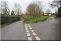
1
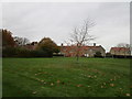
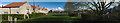
Millennium Green and cottages, Aisby
Image: © Jonathan Thacker
Taken: 6 Nov 2019
0.01 miles
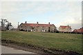
2
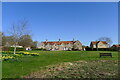
Millennium Green, Aisby
New Row cottages (19thC) situated on the edge of Aisby Millennium Green which was established in 2000. The original ancient village green is situated further downhill.
Image: © Tim Heaton
Taken: 30 Mar 2021
0.02 miles
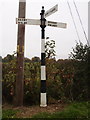
7
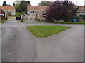
Road junction and grass triangle
Well maintained grass triangle off the beaten track of heavy lorries and farm traffic.
Image: © Michael Trolove
Taken: 30 Oct 2016
0.11 miles
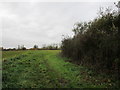
8
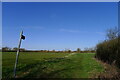
Footpath across Cow Common - from Aisby to Oasby
Image: © Tim Heaton
Taken: 30 Mar 2021
0.16 miles
9
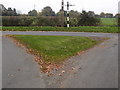
Road junction and grass triangle
Interesting signpost, not modern.
Image: © Michael Trolove
Taken: 30 Oct 2016
0.18 miles