IMAGES TAKEN NEAR TO
Oasby, GRANTHAM, NG32 3NB
Introduction
This page details the photographs taken nearby to NG32 3NB by members of the Geograph project.
The Geograph project started in 2005 with the aim of publishing, organising and preserving representative images for every square kilometre of Great Britain, Ireland and the Isle of Man.

There are currently over 7.5m images from over14,400 individuals and you can help contribute to the project by visiting https://www.geograph.org.uk
Image Map
Images are licensed for reuse under creativecommons.org/licenses/by-sa/2.0
Notes
- Clicking on the map will re-center to the selected point.
- The higher the marker number, the further away the image location is from the centre of the postcode.
Image Listing (36 Images Found)
Images are licensed for reuse under creativecommons.org/licenses/by-sa/2.0
Image
Details
Distance
1

Winter tree
Image: © Bob Harvey
Taken: 17 Feb 2019
0.02 miles
2

Walls and roofs
A variety of building materials.
The coursed stone wall, essentially laid dry, is characteristic of the village and a few others round about in the size and regularity of the coursed stonework.
Image: © Bob Harvey
Taken: 17 Feb 2019
0.02 miles
3

Sewage cover
An access hole in the street outside the pub
Image: © Bob Harvey
Taken: 17 Feb 2019
0.02 miles
4
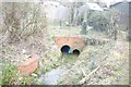
Culvert mouth
Half way along this footpath the stream is suddenly culverted.
Image: © Bob Harvey
Taken: 17 Feb 2019
0.02 miles
5
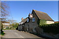
The Houblon Arms, Oasby
Listed Grade II. "The building dates from around 1650 and can trace its history as an inn nearly that far back... Originally called the Old Red Lion, the pub then took its name from the local landowner, Sir John Houblon, who was the first governor of the Bank of England. You can find his likeness on the back of an old £50 note." https://www.thehoublonarms.com/about
Image: © Tim Heaton
Taken: 30 Mar 2021
0.02 miles

8
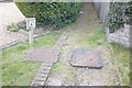
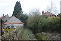
Culvert manhole
At the other end of the footpath seen in Image this large manhole lies in the path surface, giving access to the culverted stream. The lighter manhole on the left is for the second culvert seen in Image
Image: © Bob Harvey
Taken: 17 Feb 2019
0.03 miles