IMAGES TAKEN NEAR TO
Lincoln Road, GRANTHAM, NG32 3LQ
Introduction
This page details the photographs taken nearby to Lincoln Road, NG32 3LQ by members of the Geograph project.
The Geograph project started in 2005 with the aim of publishing, organising and preserving representative images for every square kilometre of Great Britain, Ireland and the Isle of Man.

There are currently over 7.5m images from over14,400 individuals and you can help contribute to the project by visiting https://www.geograph.org.uk
Image Map
Images are licensed for reuse under creativecommons.org/licenses/by-sa/2.0
Notes
- Clicking on the map will re-center to the selected point.
- The higher the marker number, the further away the image location is from the centre of the postcode.
Image Listing (5 Images Found)
Images are licensed for reuse under creativecommons.org/licenses/by-sa/2.0
Image
Details
Distance
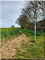
2
The track to Victoria Farm
Victoria Farm sits at the top of the lower scarp of the Lincoln edge.
Image: © Jonathan Thacker
Taken: 3 Jun 2011
0.02 miles
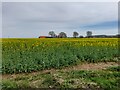
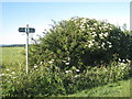
3
The bridleway to Fulbeck
This forms the boundary between the parishes of Fulbeck (on the left) and Caythorpe (on the right). The bridleway links Cliff Road (A607) and Gorse Hill Lane.
Image: © Jonathan Thacker
Taken: 3 Jun 2011
0.16 miles
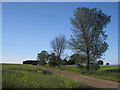
4
Junction of footpath and bridleway
Part of a network of rights of way between Caythorpe and Fulbeck.
Image: © Jonathan Thacker
Taken: 3 Jun 2011
0.24 miles