IMAGES TAKEN NEAR TO
Brant Road, GRANTHAM, NG32 3JA
Introduction
This page details the photographs taken nearby to Brant Road, NG32 3JA by members of the Geograph project.
The Geograph project started in 2005 with the aim of publishing, organising and preserving representative images for every square kilometre of Great Britain, Ireland and the Isle of Man.

There are currently over 7.5m images from over14,400 individuals and you can help contribute to the project by visiting https://www.geograph.org.uk
Image Map
Images are licensed for reuse under creativecommons.org/licenses/by-sa/2.0
Notes
- Clicking on the map will re-center to the selected point.
- The higher the marker number, the further away the image location is from the centre of the postcode.
Image Listing (6 Images Found)
Images are licensed for reuse under creativecommons.org/licenses/by-sa/2.0
Image
Details
Distance
3
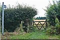
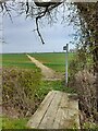
Entrance to Public Bridleway
Off Brant road.
Image: © J.Hannan-Briggs
Taken: 11 Aug 2013
0.18 miles
4
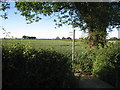
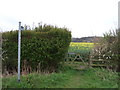
Footpath to Brant Broughton
This footpath begins in Caythorpe and here is crossing Brant Road in the parish of Fulbeck.
Image: © Jonathan Thacker
Taken: 3 Jun 2011
0.19 miles