IMAGES TAKEN NEAR TO
Fulbeck Heath, GRANTHAM, NG32 3HW
Introduction
This page details the photographs taken nearby to NG32 3HW by members of the Geograph project.
The Geograph project started in 2005 with the aim of publishing, organising and preserving representative images for every square kilometre of Great Britain, Ireland and the Isle of Man.

There are currently over 7.5m images from over14,400 individuals and you can help contribute to the project by visiting https://www.geograph.org.uk
Image Map
Images are licensed for reuse under creativecommons.org/licenses/by-sa/2.0
Notes
- Clicking on the map will re-center to the selected point.
- The higher the marker number, the further away the image location is from the centre of the postcode.
Image Listing (6 Images Found)
Images are licensed for reuse under creativecommons.org/licenses/by-sa/2.0
Image
Details
Distance
1
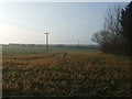
The lane to Holy Well Farm
The beginning of a footpath to Fulbeck.
Image: © Jonathan Thacker
Taken: 3 Jun 2011
0.04 miles
2
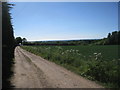
Footpath to Holy Well Farm
Passes through this field waiting to be cut for either silage or hay.
Image: © Jonathan Thacker
Taken: 3 Jun 2011
0.08 miles
3
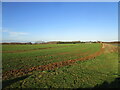
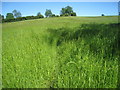
Caythorpe Heath
Looking towards Holywell Farm.
The heath was largely brought into cultivation in the nineteenth century. Prior to that it had been mainly sheep pasture.
Image: © Jonathan Thacker
Taken: 17 Dec 2020
0.14 miles
4
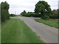
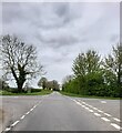
Crossroads on the Heath
These crossroads lead to Caythorpe Heath to the right and Fulbeck Heath straight on.
Image: © Michael Patterson
Taken: 5 Sep 2006
0.19 miles