IMAGES TAKEN NEAR TO
Frieston Heath Lane, GRANTHAM, NG32 3HF
Introduction
This page details the photographs taken nearby to Frieston Heath Lane, NG32 3HF by members of the Geograph project.
The Geograph project started in 2005 with the aim of publishing, organising and preserving representative images for every square kilometre of Great Britain, Ireland and the Isle of Man.

There are currently over 7.5m images from over14,400 individuals and you can help contribute to the project by visiting https://www.geograph.org.uk
Image Map
Images are licensed for reuse under creativecommons.org/licenses/by-sa/2.0
Notes
- Clicking on the map will re-center to the selected point.
- The higher the marker number, the further away the image location is from the centre of the postcode.
Image Listing (8 Images Found)
Images are licensed for reuse under creativecommons.org/licenses/by-sa/2.0
Image
Details
Distance
1
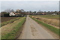
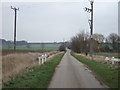
Frieston Heath Lane
Towards Frieston Grange
Image: © J.Hannan-Briggs
Taken: 23 Feb 2014
0.02 miles
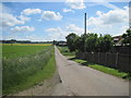
2
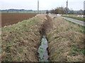
Dismantled railway north of Frieston Heath Lane
Image: © Martin Dawes
Taken: 16 Jun 2013
0.07 miles
4
Wrong Camouflage
The soldiers marching down Frieston Heath Lane are just about to vanish into the camouflage of one of the few trees in this area.
Image: © Michael Patterson
Taken: 28 Jul 2006
0.14 miles
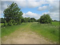
7
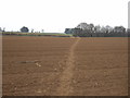
Footpath over field off Frieston Heath Lane
Image: © JThomas
Taken: 29 Feb 2012
0.17 miles
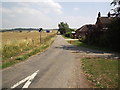
8
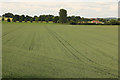
Dismantled Railway north
View north along the line of the dismantled railway from the A607 bridge between Normanton-on-Cliffe and Caythorpe
Image: © Richard Croft
Taken: 24 Jun 2015
0.17 miles