IMAGES TAKEN NEAR TO
Frieston Heath, GRANTHAM, NG32 3HE
Introduction
This page details the photographs taken nearby to Frieston Heath, NG32 3HE by members of the Geograph project.
The Geograph project started in 2005 with the aim of publishing, organising and preserving representative images for every square kilometre of Great Britain, Ireland and the Isle of Man.

There are currently over 7.5m images from over14,400 individuals and you can help contribute to the project by visiting https://www.geograph.org.uk
Image Map
Images are licensed for reuse under creativecommons.org/licenses/by-sa/2.0
Notes
- Clicking on the map will re-center to the selected point.
- The higher the marker number, the further away the image location is from the centre of the postcode.
Image Listing (3 Images Found)
Images are licensed for reuse under creativecommons.org/licenses/by-sa/2.0
Image
Details
Distance
1
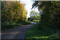
Frieston Heath Lane
Looking towards Frieston Heath Farm.
Image: © Kate Jewell
Taken: 19 Nov 2006
0.01 miles
2
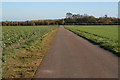
Frieston Heath Lane
Looking towards Frieston Heath Farm. The Heath is a large flat area of land, about 80 metres above sea level, stretching from Barkstone north almost to Lincoln.
Image: © Kate Jewell
Taken: 19 Nov 2006
0.13 miles
3
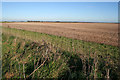
Giant field on Frieston Heath
Looking northwards towards Frieston Heath Farm from Heath Lane.
Image: © Kate Jewell
Taken: 19 Nov 2006
0.19 miles