IMAGES TAKEN NEAR TO
Caythorpe Court, GRANTHAM, NG32 3ES
Introduction
This page details the photographs taken nearby to Caythorpe Court, NG32 3ES by members of the Geograph project.
The Geograph project started in 2005 with the aim of publishing, organising and preserving representative images for every square kilometre of Great Britain, Ireland and the Isle of Man.

There are currently over 7.5m images from over14,400 individuals and you can help contribute to the project by visiting https://www.geograph.org.uk
Image Map
Images are licensed for reuse under creativecommons.org/licenses/by-sa/2.0
Notes
- Clicking on the map will re-center to the selected point.
- The higher the marker number, the further away the image location is from the centre of the postcode.
Image Listing (8 Images Found)
Images are licensed for reuse under creativecommons.org/licenses/by-sa/2.0
Image
Details
Distance
1
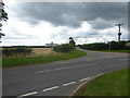
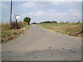
Stormy crossroads on Caythorpe Heath
This view is from the road across Caythorpe Heath from Ermine Street to Caythorpe where it meets Pottergate Road.
Image: © Marathon
Taken: 12 Aug 2017
0.14 miles
2
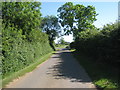
Pottergate Road
Approaching Cross Roads Farm.
Image: © Jonathan Thacker
Taken: 3 Jun 2011
0.18 miles
3
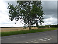
Stormy weather on Caythorpe Heath
This view is of the road across Caythorpe Heath from Ermine Street to Caythorpe near where it meets Pottergate Road.
Image: © Marathon
Taken: 12 Aug 2017
0.19 miles
4
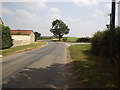
Caythorpe Crossroads
Caythorpe Heath lies beyond these crossroads.
Image: © Michael Patterson
Taken: 28 Jul 2006
0.19 miles
5
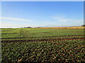
Autumn sown crop, Caythorpe Heath
The stone wall which forms the boundary is in much better condition than most in this area.
Image: © Jonathan Thacker
Taken: 17 Dec 2020
0.22 miles
6
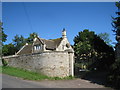
The gates and lodge to Caythorpe Court
Caythorpe Court has undergone many changes from private house and farm to agricultural college to a branch of De Montfort University to a children's holiday centre.
Image: © Jonathan Thacker
Taken: 3 Jun 2011
0.23 miles
7
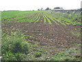
Sugar beet on Caythorpe Heath
The crop will eventually be processed at the British Sugar factory at Newark. Note the stone wall which is fairly typical of the area.
Image: © Jonathan Thacker
Taken: 3 Jun 2011
0.24 miles
8
Changed Name Farm
Hill Top Farm went by the name of Caythorpe Heath Farm according to the 1940s OS map.
Image: © Michael Patterson
Taken: 28 Jul 2006
0.24 miles