IMAGES TAKEN NEAR TO
Caythorpe Court, GRANTHAM, NG32 3ER
Introduction
This page details the photographs taken nearby to Caythorpe Court, NG32 3ER by members of the Geograph project.
The Geograph project started in 2005 with the aim of publishing, organising and preserving representative images for every square kilometre of Great Britain, Ireland and the Isle of Man.

There are currently over 7.5m images from over14,400 individuals and you can help contribute to the project by visiting https://www.geograph.org.uk
Image Map
Images are licensed for reuse under creativecommons.org/licenses/by-sa/2.0
Notes
- Clicking on the map will re-center to the selected point.
- The higher the marker number, the further away the image location is from the centre of the postcode.
Image Listing (6 Images Found)
Images are licensed for reuse under creativecommons.org/licenses/by-sa/2.0
Image
Details
Distance
1
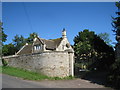
The gates and lodge to Caythorpe Court
Caythorpe Court has undergone many changes from private house and farm to agricultural college to a branch of De Montfort University to a children's holiday centre.
Image: © Jonathan Thacker
Taken: 3 Jun 2011
0.05 miles
2
Changed Name Farm
Hill Top Farm went by the name of Caythorpe Heath Farm according to the 1940s OS map.
Image: © Michael Patterson
Taken: 28 Jul 2006
0.07 miles
3
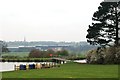
Lake at the outdoor activities centre, Caythorpe Court
Caythorpe Court was home to the Kesteven Agricultural College from 1946 to 2002. It is now an activity centre. The figure-of-eight shaped lake was dug recently for raft-building activities. In the middle distance are the buildings of the materials recycling facility on the site of the old station at Caythorpe, and beyond that, the spire of Caythorpe church.
Image: © Simon Mortimer
Taken: 11 Apr 2009
0.20 miles
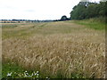
4
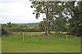
The undulating topography near the memorial to the crew of Stirling LJ450
Very close by is the memorial to the crew of Stirling LJ450
https://www.geograph.org.uk/photo/6503576
Image: © Adrian S Pye
Taken: 8 Jun 2020
0.20 miles
5
Memorial to the crew of Stirling LJ450, 12 April 1944
1654 HCU. (Heavy Conversion Unit), Stirling LJ450 UG-F, had departed RAF Wigsley for a long-range night Navex, (Navigation Exercise) on 12/04/1944, combined with some bombing practise on Bassingham Fen range.
Whilst operating over the range it was intercepted by a Luftwaffe Me410 intruder and shot down.
The aircraft crashed at Caythorpe Heath at 0125hrs. Four of the eight-man crew were killed, the others were injured but survived.
The crew who died were:
Pilot; Flt Sgt. Joseph John Gordon NICHOLSON, RAFVR, age 28
Navigator; Sgt. John Ernest LOWE, RAFVR, age 22
Bomb Aimer; Sgt. Gwilym John LEWIS, RAFVR, age 20
Air Gunner; Sgt. Kenneth Lowe MacFARLANE, RAFVR, age 20
Crew who managed to bail out:
Sgt. DURHAM,
Sgt. HOWELL,
Sgt. ROWLAND,
Sgt. HAMILTON
The copse in which the memorial is situated has been allowed to grow up around the crash site as a memorial by the Theaker family who witnessed the crash and "in respect for those who sacrificed so much."
Image: © Adrian S Pye
Taken: 8 Jun 2020
0.22 miles
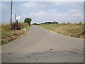
6
View from Caythorpe Heath Lane
This view is from the road across Caythorpe Heath from Ermine Street to Caythorpe. Here it is known as Caythorpe Heath Lane.
Image: © Marathon
Taken: 12 Aug 2017
0.24 miles