IMAGES TAKEN NEAR TO
High Street, GRANTHAM, NG32 3DP
Introduction
This page details the photographs taken nearby to High Street, NG32 3DP by members of the Geograph project.
The Geograph project started in 2005 with the aim of publishing, organising and preserving representative images for every square kilometre of Great Britain, Ireland and the Isle of Man.

There are currently over 7.5m images from over14,400 individuals and you can help contribute to the project by visiting https://www.geograph.org.uk
Image Map
Images are licensed for reuse under creativecommons.org/licenses/by-sa/2.0
Notes
- Clicking on the map will re-center to the selected point.
- The higher the marker number, the further away the image location is from the centre of the postcode.
Image Listing (106 Images Found)
Images are licensed for reuse under creativecommons.org/licenses/by-sa/2.0
Image
Details
Distance
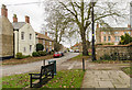
1
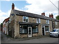
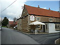
Commercial premises, High Street, Caythorpe
Image: © Jonathan Thacker
Taken: 13 Aug 2023
0.01 miles
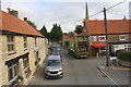
2
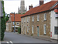
Caythorpe - east side of north end of High Street
Image: © Dave Bevis
Taken: 30 Jun 2014
0.01 miles
3
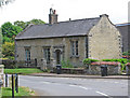
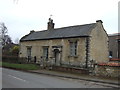
Caythorpe - former school
At No 3 Church Lane. Built in 1832 and now a house. For more information on the building, please see http://www.britishlistedbuildings.co.uk/en-193124-3-church-lane-caythorpe-lincolnshire . For a closer view of the north side of this building, please see Image The current primary school is pictured at Image
Image: © Dave Bevis
Taken: 30 Jun 2014
0.02 miles
4
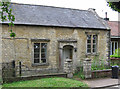
Caythorpe - former school - north side
For a wider view of this building, please see Image
Image: © Dave Bevis
Taken: 30 Jun 2014
0.02 miles
5
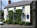
Caythorpe - residential home on High Street
Image: © Dave Bevis
Taken: 30 Jun 2014
0.02 miles
6
A waste collection lorry stops outside The Red Lion on High Street
Image: © Roger Templeman
Taken: 11 Sep 2019
0.02 miles
7
The Red Lion, Caythorpe
One of two pubs in the village, both located on the High Street.
Image: © Jonathan Billinger
Taken: 9 Apr 2008
0.03 miles
9
Church Lane, Caythorpe
The church, which was behind the photographer, was having its roof replaced, and was covered with scaffolding.
Image: © Julian P Guffogg
Taken: 10 Nov 2015
0.03 miles
10
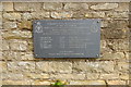
Memorial to the crew of Lancaster PB812, 10/02/1945
The memorial is attached to the churchyard wall of St. Vincent's church.
https://www.geograph.org.uk/photo/5500633
Lancaster PB812, AR-Y, 460 Sqdn, out of Binbrook on a cross country navigation exercise (Navex).
At 3.45pm, as it was returning to Binbrook it crashed close to Caythorpe railway station.
It was seen to dive almost vertically into the ground with flames coming from both wings.
All 6 of those on-board were killed:
Pilot; Plt Off. Richard Albert George MILLER, RAAF, age 27
Flight Engineer; Flt Sgt. Frederick Albert Cecil NESBIT-BELL, RAFVR age 27
Navigator; Flg Off. Jeffrey John DOWNING, RAAF, age 22
Wireless Op./Air Gunner; Flt Sgt. Rhodric Leslie POPE, RAAF, age 19
Air Gunner; Flt Sgt. Graeme Mark DOCKERY, RAAF, age 21
Bomb Aimer; Anthony Gatward ROBINSON, RAAF, age 19.
A second memorial, close to the crash site is located in Love Lane.
https://www.geograph.org.uk/photo/6503496
Image: © Adrian S Pye
Taken: 8 Jun 2020
0.04 miles