IMAGES TAKEN NEAR TO
Frieston, GRANTHAM, NG32 3DA
Introduction
This page details the photographs taken nearby to NG32 3DA by members of the Geograph project.
The Geograph project started in 2005 with the aim of publishing, organising and preserving representative images for every square kilometre of Great Britain, Ireland and the Isle of Man.

There are currently over 7.5m images from over14,400 individuals and you can help contribute to the project by visiting https://www.geograph.org.uk
Image Map
Images are licensed for reuse under creativecommons.org/licenses/by-sa/2.0
Notes
- Clicking on the map will re-center to the selected point.
- The higher the marker number, the further away the image location is from the centre of the postcode.
Image Listing (8 Images Found)
Images are licensed for reuse under creativecommons.org/licenses/by-sa/2.0
Image
Details
Distance
1
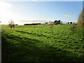
Former ironstone quarry
This area was quarried from 1924 to 1940 by W. Burke and Co. Ltd.
Image: © Jonathan Thacker
Taken: 12 Nov 2020
0.05 miles
3
Hough Road bridge
This bridge enabled Hough Road to cross a railway operated by W. Burke & Co. Ltd. as part of that company's ironstone quarrying operation. The quarry here was operated from 1924 to 1940. However, the route of the railway must have proved useful to the farmer who later occupied the former quarry area and the bridge has been maintained rather than infilled as is usually the case.
Image: © Jonathan Thacker
Taken: 12 Nov 2020
0.07 miles
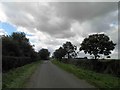
5
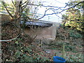
Hough Road bridge
This bridge enabled Hough Road to cross a railway operated by W. Burke & Co. Ltd. as part of that company's ironstone quarrying operation. The quarry here was operated from 1924 to 1940. However, the route of the railway must have proved useful to the farmer who later occupied the former quarry area and the bridge has been maintained rather than infilled as is usually the case.
Image: © Jonathan Thacker
Taken: 12 Nov 2020
0.08 miles
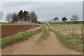
6
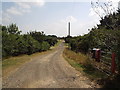
Track to Lakeside
This track leads to former ironstone workings as well as to Lakeside Farm.
Image: © Michael Patterson
Taken: 28 Jul 2006
0.12 miles
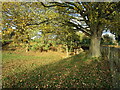
7
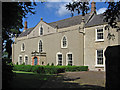
Frieston - Old Hall
On Hough Road. For more information on this building, please see http://www.britishlistedbuildings.co.uk/en-193152-frieston-hall-caythorpe-lincolnshire .
Image: © Dave Bevis
Taken: 30 Jun 2014
0.18 miles
8
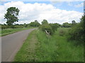
Entrance to former ironstone quarry
The area around Caythorpe was once extensively quarried for ironstone. This was one such quarry as can be seen by the level of the land to the right of the road.
Image: © Jonathan Thacker
Taken: 6 Jun 2012
0.20 miles