IMAGES TAKEN NEAR TO
Frieston Path, GRANTHAM, NG32 3BU
Introduction
This page details the photographs taken nearby to Frieston Path, NG32 3BU by members of the Geograph project.
The Geograph project started in 2005 with the aim of publishing, organising and preserving representative images for every square kilometre of Great Britain, Ireland and the Isle of Man.

There are currently over 7.5m images from over14,400 individuals and you can help contribute to the project by visiting https://www.geograph.org.uk
Image Map
Images are licensed for reuse under creativecommons.org/licenses/by-sa/2.0
Notes
- Clicking on the map will re-center to the selected point.
- The higher the marker number, the further away the image location is from the centre of the postcode.
Image Listing (23 Images Found)
Images are licensed for reuse under creativecommons.org/licenses/by-sa/2.0
Image
Details
Distance
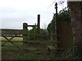
1
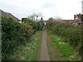
Footpath to Millfield Crescent, Caythorpe
Image: © Jonathan Thacker
Taken: 5 Mar 2024
0.05 miles
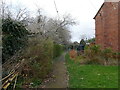
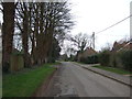
4
Footpath from Hough on the Hill
Approaching South Parade, Caythorpe.
Image: © Jonathan Thacker
Taken: 5 Mar 2024
0.08 miles
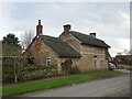
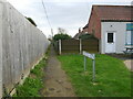
8
High Street, Caythorpe
The house on the corner (and the adjacent Post Office) have been altered at some time.
Image: © Jonathan Thacker
Taken: 5 Mar 2024
0.11 miles
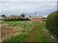
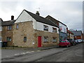
9
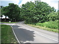
The junction of Lincoln Road and High Street, Caythorpe
Long ago the road to Lincoln would have been via the High Street and then at a later date along what is now Old Lincoln Road.
Image: © Jonathan Thacker
Taken: 6 Jun 2012
0.14 miles
10
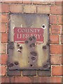
Old sign on Caythorpe school
See http://www.geograph.org.uk/photo/3244871 for a wider view.
Image: © Brian Westlake
Taken: 2 Aug 2012
0.15 miles