IMAGES TAKEN NEAR TO
Hough Lane, GRANTHAM, NG32 3BB
Introduction
This page details the photographs taken nearby to Hough Lane, NG32 3BB by members of the Geograph project.
The Geograph project started in 2005 with the aim of publishing, organising and preserving representative images for every square kilometre of Great Britain, Ireland and the Isle of Man.

There are currently over 7.5m images from over14,400 individuals and you can help contribute to the project by visiting https://www.geograph.org.uk
Image Map
Images are licensed for reuse under creativecommons.org/licenses/by-sa/2.0
Notes
- Clicking on the map will re-center to the selected point.
- The higher the marker number, the further away the image location is from the centre of the postcode.
Image Listing (6 Images Found)
Images are licensed for reuse under creativecommons.org/licenses/by-sa/2.0
Image
Details
Distance
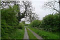
2
Newark Lane near Carlton Scroop Hall
Heading east.
Image: © J.Hannan-Briggs
Taken: 23 Feb 2014
0.19 miles
4
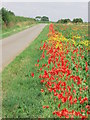
Poppies alongside Newark Lane, Carlton Scroop
Image: © Colin Park
Taken: 20 Jul 2014
0.21 miles
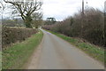
5
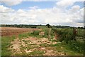
View to Normanton
Looking east from Carlton Road towards Normanton and the cliff
Image: © Richard Croft
Taken: 21 Jun 2007
0.22 miles
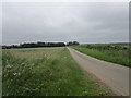
6
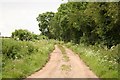
Howdale Lane
The Viking Way heading west from Carlton Scroop
Image: © Richard Croft
Taken: 21 Jun 2007
0.23 miles