IMAGES TAKEN NEAR TO
Frinkley Road, GRANTHAM, NG32 2PS
Introduction
This page details the photographs taken nearby to Frinkley Road, NG32 2PS by members of the Geograph project.
The Geograph project started in 2005 with the aim of publishing, organising and preserving representative images for every square kilometre of Great Britain, Ireland and the Isle of Man.

There are currently over 7.5m images from over14,400 individuals and you can help contribute to the project by visiting https://www.geograph.org.uk
Image Map
Images are licensed for reuse under creativecommons.org/licenses/by-sa/2.0
Notes
- Clicking on the map will re-center to the selected point.
- The higher the marker number, the further away the image location is from the centre of the postcode.
Image Listing (14 Images Found)
Images are licensed for reuse under creativecommons.org/licenses/by-sa/2.0
Image
Details
Distance
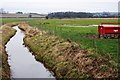
1
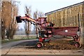
Sugar beet elevator at Honington Grange
Image: © Simon Mortimer
Taken: 30 Dec 2008
0.04 miles

6
Honington Beck in a snowstorm
The distant mist is actually snow which has not settled yet.
Image: © J.Hannan-Briggs
Taken: 10 Mar 2013
0.11 miles
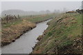
7
Honington Beck
Looking upstream from the Frinkley Lane bridge.
Image: © Simon Mortimer
Taken: 28 Dec 2008
0.11 miles
8
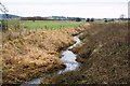
Honington Beck
Looking downstream from the Frinkley Lane bridge, towards Barkston.
Image: © Simon Mortimer
Taken: 28 Dec 2008
0.12 miles
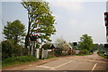
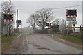
10
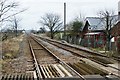
Frinkley Lane level crossing
View looking along the line towards Sleaford.
Image: © Simon Mortimer
Taken: 28 Dec 2008
0.13 miles