IMAGES TAKEN NEAR TO
Sleaford Road, GRANTHAM, NG32 2PP
Introduction
This page details the photographs taken nearby to Sleaford Road, NG32 2PP by members of the Geograph project.
The Geograph project started in 2005 with the aim of publishing, organising and preserving representative images for every square kilometre of Great Britain, Ireland and the Isle of Man.

There are currently over 7.5m images from over14,400 individuals and you can help contribute to the project by visiting https://www.geograph.org.uk
Image Map
Images are licensed for reuse under creativecommons.org/licenses/by-sa/2.0
Notes
- Clicking on the map will re-center to the selected point.
- The higher the marker number, the further away the image location is from the centre of the postcode.
Image Listing (5 Images Found)
Images are licensed for reuse under creativecommons.org/licenses/by-sa/2.0
Image
Details
Distance
1
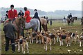
Belvoir hunt meeting
Hunt gathering at Honington House. The woodland on the edge of Honington Heath can be seen in the background.
Image: © Simon Mortimer
Taken: 30 Dec 2008
0.02 miles
2
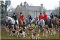
Belvoir Hunt meet at Honington House
New Year's Eve meeting of the Belvoir Hunt.
Image: © Simon Mortimer
Taken: 30 Dec 2008
0.02 miles
3
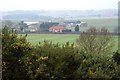
Honington House
Viewed from the area of rough grassland and gorse adjacent to Roger's Plantation.
Image: © Simon Mortimer
Taken: 30 Dec 2008
0.03 miles
4
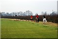
Belvoir Hunt and hounds
Skirting the edge of a field of turf grass adjacent to the A153.
Image: © Simon Mortimer
Taken: 30 Dec 2008
0.10 miles
5
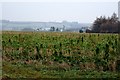
Winter farmland at Honington
Looking over the fields from the edge of Honington towards Honington House.
Image: © Simon Mortimer
Taken: 30 Dec 2008
0.23 miles