IMAGES TAKEN NEAR TO
Barkston, GRANTHAM, NG32 2NY
Introduction
This page details the photographs taken nearby to NG32 2NY by members of the Geograph project.
The Geograph project started in 2005 with the aim of publishing, organising and preserving representative images for every square kilometre of Great Britain, Ireland and the Isle of Man.

There are currently over 7.5m images from over14,400 individuals and you can help contribute to the project by visiting https://www.geograph.org.uk
Image Map
Images are licensed for reuse under creativecommons.org/licenses/by-sa/2.0
Notes
- Clicking on the map will re-center to the selected point.
- The higher the marker number, the further away the image location is from the centre of the postcode.
Image Listing (11 Images Found)
Images are licensed for reuse under creativecommons.org/licenses/by-sa/2.0
Image
Details
Distance
2
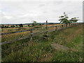
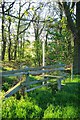
Stile at Peascliff Farm
There are several stiles in quick succession near Peascliffe Farm on the footpath from Great Gonerby to Syston. It is tedious having to lift a dog over each one.
Image: © Jonathan Thacker
Taken: 14 Jul 2019
0.08 miles
3
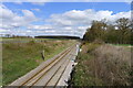
Emerging Line
Looking North along the railway as it emerges from the Peasscliff Tunnel
Image: © Glyn Baker
Taken: 12 May 2012
0.08 miles
4
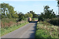
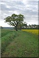
Gonnerby Grange Bridge, Peascliffe Lane
The London to Edinburgh high speed rail link passes under this bridge in a deep cutting.
Image: © Kate Jewell
Taken: 29 Oct 2006
0.11 miles
5
Path Across the Tunnel
This footpath crosses over the path of the Peascliff Railway Tunnel
Image: © Glyn Baker
Taken: 12 May 2012
0.14 miles
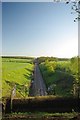
6
Footpath to Great Gonerby crossing over Peascliff Tunnel
The tunnel carries the East Coast Main Line.
Image: © Tim Heaton
Taken: 15 Apr 2021
0.14 miles
7
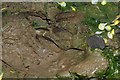
Fallow Deer Track
If I had had my telephoto lens on the camera and not in the bag you could have had a picture of the deer who made this print. We stood and looked at each other for a moment and then the creature bounded off.
Image: © Glyn Baker
Taken: 13 May 2012
0.20 miles
8
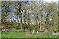
Oak Pollards
A field boundary marked by a ditch and a line of Oak Pollards
Image: © Glyn Baker
Taken: 13 May 2012
0.21 miles
9
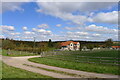
The East Coast Main Line running north from Peascliff Tunnel
Image: © Tim Heaton
Taken: 15 Apr 2021
0.24 miles
10
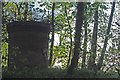
Peascliff Tunnel Air Shaft
The railway tunnel air Shaft was photographed from the quad bike trail of the Belton Woods Hotel.
Image: © Glyn Baker
Taken: 12 May 2012
0.25 miles