IMAGES TAKEN NEAR TO
Belton, GRANTHAM, NG32 2NX
Introduction
This page details the photographs taken nearby to NG32 2NX by members of the Geograph project.
The Geograph project started in 2005 with the aim of publishing, organising and preserving representative images for every square kilometre of Great Britain, Ireland and the Isle of Man.

There are currently over 7.5m images from over14,400 individuals and you can help contribute to the project by visiting https://www.geograph.org.uk
Image Map
Images are licensed for reuse under creativecommons.org/licenses/by-sa/2.0
Notes
- Clicking on the map will re-center to the selected point.
- The higher the marker number, the further away the image location is from the centre of the postcode.
Image Listing (4 Images Found)
Images are licensed for reuse under creativecommons.org/licenses/by-sa/2.0
Image
Details
Distance
1
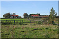
Gonerby Grange near Belton
A large farm complex on Peascliffe Lane.
Image: © Kate Jewell
Taken: 29 Oct 2006
0.03 miles
2
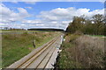
The East Coast Main Line running north from Peascliff Tunnel
Image: © Tim Heaton
Taken: 15 Apr 2021
0.22 miles
3
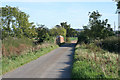
Gonnerby Grange Bridge, Peascliffe Lane
The London to Edinburgh high speed rail link passes under this bridge in a deep cutting.
Image: © Kate Jewell
Taken: 29 Oct 2006
0.24 miles
4
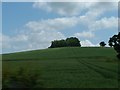
100 metre Woodland
Hill top plantation that is a marker for the 100metre contour line. It lies to the West of Gonerby Grange.
Image: © Donnylad
Taken: 5 Jun 2007
0.24 miles