IMAGES TAKEN NEAR TO
Station Road, GRANTHAM, NG32 2NT
Introduction
This page details the photographs taken nearby to Station Road, NG32 2NT by members of the Geograph project.
The Geograph project started in 2005 with the aim of publishing, organising and preserving representative images for every square kilometre of Great Britain, Ireland and the Isle of Man.

There are currently over 7.5m images from over14,400 individuals and you can help contribute to the project by visiting https://www.geograph.org.uk
Image Map
Images are licensed for reuse under creativecommons.org/licenses/by-sa/2.0
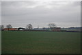
Notes
- Clicking on the map will re-center to the selected point.
- The higher the marker number, the further away the image location is from the centre of the postcode.
Image Listing (18 Images Found)
Images are licensed for reuse under creativecommons.org/licenses/by-sa/2.0
Image
Details
Distance
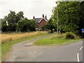
2
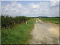
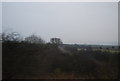
Farm track near Westfield Farm
Not a public right of way.
Image: © Jonathan Thacker
Taken: 16 Jul 2019
0.11 miles
5
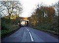
Rail bridge carrying the East Coast main line
Image: © Steve Fareham
Taken: 3 Dec 2008
0.18 miles
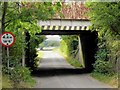
7
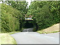
Low Bridge carrying the main East Coast line
Image: © David Harris
Taken: 20 Jul 2008
0.20 miles
8
Barkston East
Wider shot of Barkston East signal Box, now demolished
Image: © Donnylad
Taken: 22 Jan 2005
0.20 miles
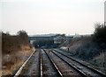
10
Railway Bridge, Barkston South Junction
Image: © David Dixon
Taken: 7 Aug 2014
0.21 miles