IMAGES TAKEN NEAR TO
Fallow Lane, GRANTHAM, NG32 2LJ
Introduction
This page details the photographs taken nearby to Fallow Lane, NG32 2LJ by members of the Geograph project.
The Geograph project started in 2005 with the aim of publishing, organising and preserving representative images for every square kilometre of Great Britain, Ireland and the Isle of Man.

There are currently over 7.5m images from over14,400 individuals and you can help contribute to the project by visiting https://www.geograph.org.uk
Image Map
Images are licensed for reuse under creativecommons.org/licenses/by-sa/2.0
Notes
- Clicking on the map will re-center to the selected point.
- The higher the marker number, the further away the image location is from the centre of the postcode.
Image Listing (16 Images Found)
Images are licensed for reuse under creativecommons.org/licenses/by-sa/2.0
Image
Details
Distance
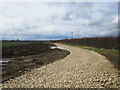
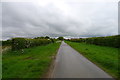
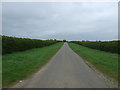
1
Bridleway to Marston
Part of the Viking Way.
Image: © Jonathan Thacker
Taken: 10 Mar 2022
0.01 miles
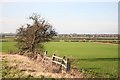
2
The Viking Way
Walkers on the Viking Way with Loveden Hill http://www.geograph.org.uk/photo/3027416 on the horizon
Image: © Richard Croft
Taken: 27 May 2013
0.07 miles
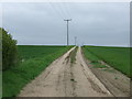
4
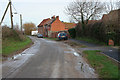
Long Street, Foston
Looking towards North End Farm.
As the road leaves the village, just past these cottages, it turns into Fallow Lane.
Image: © Kate Jewell
Taken: 30 Dec 2006
0.14 miles
5
Foston view
View towards Long Bennington from Foston
Image: © Richard Croft
Taken: 27 Jan 2008
0.16 miles
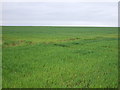
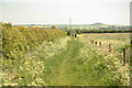
8
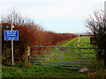
Viking Way long distance footpath
Heading east from Fallow Lane towards Image
Image: © Kate Jewell
Taken: 30 Dec 2006
0.20 miles