IMAGES TAKEN NEAR TO
Goosegate Lane, GRANTHAM, NG32 2LB
Introduction
This page details the photographs taken nearby to Goosegate Lane, NG32 2LB by members of the Geograph project.
The Geograph project started in 2005 with the aim of publishing, organising and preserving representative images for every square kilometre of Great Britain, Ireland and the Isle of Man.

There are currently over 7.5m images from over14,400 individuals and you can help contribute to the project by visiting https://www.geograph.org.uk
Image Map
Images are licensed for reuse under creativecommons.org/licenses/by-sa/2.0
Notes
- Clicking on the map will re-center to the selected point.
- The higher the marker number, the further away the image location is from the centre of the postcode.
Image Listing (45 Images Found)
Images are licensed for reuse under creativecommons.org/licenses/by-sa/2.0
Image
Details
Distance
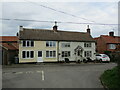
2
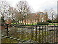
The Malting House
A building of two ages but three types of stone.
Image: © Jonathan Thacker
Taken: 10 Mar 2022
0.04 miles
3
Long Street, Foston
The buildings on the far right are part of a newly converted complex of farm buildings at Highfield Farm.
Image: © Kate Jewell
Taken: 30 Dec 2006
0.05 miles
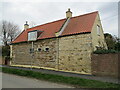
4
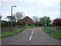
Top Farm
By far the largest house in Foston.
Image: © Jonathan Thacker
Taken: 28 Mar 2016
0.06 miles
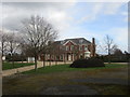
5
Top Farm, Foston
Large house in a sort of Neo Queen Anne style.
Image: © Jonathan Thacker
Taken: 10 Mar 2022
0.06 miles
8
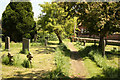
Church path
Path to Long Street in St.Peter's churchyard
Image: © Richard Croft
Taken: 27 May 2013
0.12 miles
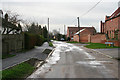
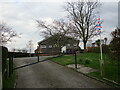
10
The end of Church Street and the beginning of a footpath to Westborough
Image: © Jonathan Thacker
Taken: 28 Mar 2016
0.13 miles