IMAGES TAKEN NEAR TO
Frinkley Lane, GRANTHAM, NG32 2JQ
Introduction
This page details the photographs taken nearby to Frinkley Lane, NG32 2JQ by members of the Geograph project.
The Geograph project started in 2005 with the aim of publishing, organising and preserving representative images for every square kilometre of Great Britain, Ireland and the Isle of Man.

There are currently over 7.5m images from over14,400 individuals and you can help contribute to the project by visiting https://www.geograph.org.uk
Image Map
Images are licensed for reuse under creativecommons.org/licenses/by-sa/2.0
Notes
- Clicking on the map will re-center to the selected point.
- The higher the marker number, the further away the image location is from the centre of the postcode.
Image Listing (10 Images Found)
Images are licensed for reuse under creativecommons.org/licenses/by-sa/2.0
Image
Details
Distance
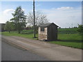
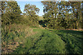
2
Frinkley Lane
Ancient byway between Honington and Hougham with the spire of St.Mary's church at Marston in the distance
Image: © Richard Croft
Taken: 13 Nov 2010
0.06 miles
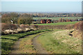
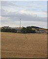
3
View to Frinkley Farm
Although the farm buildings on the right are out of this square everything else is in.
Image: © N Chadwick
Taken: 25 Feb 2011
0.11 miles
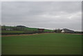
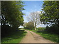
4
Frinkley Lane
Looking towards Frinkley Farm.
Image: © Jonathan Thacker
Taken: 27 Apr 2014
0.12 miles

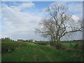
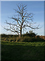
7
Frinkley Lane
Immediately to the east of Frinkley Farm.
Image: © Jonathan Thacker
Taken: 27 Apr 2014
0.15 miles
10
Public byway, Frinkley Lane
A real green Green Road!
Image: © Kate Jewell
Taken: 7 Oct 2006
0.25 miles